Posts for June, 2019
Return to NT (Keep River NP, Northern Territory)
Journal entry for Saturday 1st Jun, 2019 (day 96, kms 82)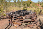
Today we ducked back into the Northern Territory a few kilometers to visit, and camp at, Keep River National Park. On paper the attractions of this park are a couple of nice campgrounds and a couple of interesting walks amongst some sandstone cliffs. The first of the days hikes introduced us to the small stone and twig structure in the first picture, which was explained by the info-plaques in pictures 2 and 3.
...click/tap to read the full postAn early morning hike (Kununurra, Western Australia)
Journal entry for Sunday 2nd Jun, 2019 (day 97, kms 78)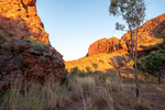
We were up well before sunrise this morning as we had decided to undertake the Jarnem Loop hike and all the advice we had read suggested getting to the lookout for the sunrise. Well we did not quite manage a sunrise at the lookout but we did get some photos of the rising suns rays on the sandstone cliffs. Towards the end of the loop we came to Nigli Gap; a series of cliffs which show signs of aboriginal habitation.
...click/tap to read the full postEl Questro (El Questro, Western Australia)
Journal entry for Monday 3rd Jun, 2019 (day 98, kms 112)
Before getting underway this morning we took a few photos around our campground, and around the town of Kununurra. In particular we wanted to demonstrate the relative lushness of the area as the Ord River Valley around Kununurra is the region that is irrigated by the water released from Lake Argyle.
...click/tap to read the full postSome exploration (El Questro, Western Australia)
Journal entry for Tuesday 4th Jun, 2019 (day 99, kms 77)
We spent the day exploring some of El Questro's attractions. In particular we took the hike into El Questro Gorge and while the walking was difficult for us the lush vegetation and crystal clear pools were very attractive. To add a bit of excitement the vehicle track to the start of the El Questro Gorge walk had a long water crossing.
...click/tap to read the full postStarting the Gibb (Ellenbrae Station, Western Australia)
Journal entry for Wednesday 5th Jun, 2019 (day 100, kms 174)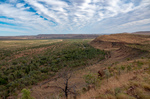
We started the day with a little bit of a 4x4 adventure on an El Questro track called Saddle Back Ridge. A long steep climb with lots of "steps" and a few off camber hairpins before arriving at a lookout that gave a good 360 degree view of the property. That seemed like a good note on which to take our leave from El Questro and start the "famous" Gibb River road.
...click/tap to read the full postCorrect handling of a cane toad (Drysdale Station, Western Australia)
Journal entry for Thursday 6th Jun, 2019 (day 101, kms 132)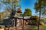
Before leaving Ellenbrae this morning we drove back to the homestead to try their coffee and scones. This seems to be a feature they are trying to cultivate as a "differentiator" for their tourist business. While sitting in the quirky but attractive cafe devouring said coffee and scones we started reading an information sheet that is provided at each table. From it we learned some interesting facts.
...click/tap to read the full postKimberley Plateau (Mitchell Falls, Western Australia)
Journal entry for Friday 7th Jun, 2019 (day 102, kms 186)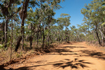
It's a bit hard to put into words the contradictions that today brings. On the one hand we are in an incredibly remote place and on the other hand tonights campground will have quite a population (maybe 100 people), we will see a number of offroad tourist buses at the campground, and there will be a helicopter base at the campground. Our starting point for today is already 500km (310miles) from the last town we passed through (Kununurra), it is the only fuel stop we have seen since that town, and today we are going to drive another 185 km (110miles) north and west from Drysdale.
...click/tap to read the full postMitchell Falls (Mitchell Falls, Western Australia)
Journal entry for Saturday 8th Jun, 2019 (day 103, kms 0)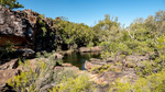
Today is one of the big days for this trip. This region, known as The Kimberley, is one of the remotest and least populated parts of Australia and the Mitchell Falls is perhaps its most iconic tourist attraction. It is also the attraction that stretched this particular adventure for us to 6 months from its original conception of half that much time (originally we were planning a 3 month trip to Australia and then Nina found Destination Kimberley and the plan got extended to 6 months). So its a big day.
...click/tap to read the full postAboriginal art (Drysdale Station, Western Australia)
Journal entry for Sunday 9th Jun, 2019 (day 104, kms 184)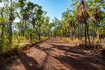
The route between Drysdale Station and the Mitchell campground consists of two road segments. From Drysdale one follows the Kalumburra Road north for 100km and then turns west onto the Mitchell Plateau track for 80km. So of course todays return journey to Drysdale reversed that route. As mentioned previously much of tne Mitchell Plateau track travels through Livistona Palm forest which we both really enjoyed. Just west of the junction of the Mitchell track and Kalumburra Road is an Aboriginal Art Site that we missed on the way up but called in on todays return.
...click/tap to read the full postReturn to the Gibb (Manning Gorge, Western Australia)
Journal entry for Monday 10th Jun, 2019 (day 105, kms 171)
With our Mitchell excursion done today we returned to the Gibb River Road and continued our westward journey. The first leg of the days journey was 60km south from Drysdale to the Gibb River Rest area and then 110 west to Mount Barnett Road House and the nearby Manning Gorge Campground. There was not much of note on todays drive, lots of road corrugations, a surprising number of fellow travellers, maybe 50 other cars most towing a camper of some form and two notable river crossings where we took a few photos. We crossed the Gibb River just before rejoining the Gibb River Road and the Barnett River just before the similarly named road house.
...click/tap to read the full postFreshies (Windjana NP, Western Australia)
Journal entry for Tuesday 11th Jun, 2019 (day 106, kms 205)
We made a start before sunrise this morning and walked from the campground to Manning Gorge. The start of the walk is quite interesting as one has to cross a large waterhole, and a small aluminium boat with rope tow is provided for the purpose. By the time we returned from the walk the kids staying in the campground were up and playing in the waterhole and a couple of them offered to be our ferrymen. The walk to the Gorge was hot and a bit tedious but the gorge provided some nice photos of cliffs reflected in the clear water.
...click/tap to read the full postCrocs and bats (Windjana NP, Western Australia)
Journal entry for Wednesday 12th Jun, 2019 (day 107, kms 72)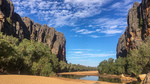
This morning we visited another attraction of the Napier Range, Tunnel Creek about 35km south of Windjana. The "tunnel" which is about 750 meters long is nothing more than a small limestone cave carved out by a wet season river/creek. The thing that sets this cave apart from other limestone caves are the resident fresh water crocodiles. The one in picture 8 is real. This cave was once the hideout of an aboriginal outlaw or freedom fighter (depending on your perspective) name Pigeon or Jandamarra. See Tunnell Creek
...click/tap to read the full postCompleting the Gibb (Broome, Western Australia)
Journal entry for Thursday 13th Jun, 2019 (day 108, kms 367)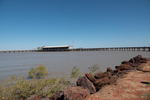
Today turned into a long day, at least by our standards. We got an early start from Windjana, eventually the paved road arrived and we made good time into the coastal town of Derby on King Sound at the mouth of the Fitzroy River. We found the place a little crowded (with tourists), and the single campground seemed packed so we decided to push on to Broome.
...click/tap to read the full postCape Leveque (Gumbanan, Western Australia)
Journal entry for Sunday 16th Jun, 2019 (day 111, kms 279)
We have a few things planned in Broome next week but the thought of hanging around in one place for over a week was more than Nina could tolerate so we decided to take a little excursion to Cape Leveque about 200km north of Broome. The peninsula that is tipped by Cape Leveque is all aboriginal land and hence is very lightly inhabited but non the less is a very popular tourist destination.
...click/tap to read the full postReturn to Broome (Broome, Western Australia)
Journal entry for Monday 17th Jun, 2019 (day 112, kms 228)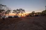
Before returning to Broome this morning we wanted to visit Kooljaman, an aboriginal owned tourist resort that provides accommodation ranging from luxury cabins through to unpowered campsites. They were fully booked so we could not camp there last night. Also this property is the only place where one can access the beach front at Cape Leveque. Photo 2 is the access road to Kooljaman. We spent a couple of hours at Kooljaman exploring their beaches and facilities before starting the return trip to Broome.
...click/tap to read the full postStairway to the Moon (Broome, Western Australia)
Journal entry for Tuesday 18th Jun, 2019 (day 113, kms 0)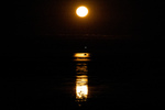
One of the big events in Broome is called Stairway to the Moon. This takes place whenever a low tide and new moon coincide. Since the downtown beach area of Broome face East one can watch the new full moon rise over the sea, and when the tide is low the moon light reflects off the sand/mud to give the impression of stairs leading to the rising moon. This is now a big event and attracts thousands of spectators. So this evening about 6:17pm we were at the Town Beach to buy dinner from one of the many food stalls and watch the moon rise. Photos were difficult.
...click/tap to read the full postHorizontal Falls (Broome, Western Australia)
Journal entry for Wednesday 19th Jun, 2019 (day 114, kms 0)
Today we visited and "rode" a tidal phenomena called The Horizontal Falls. These falls are located about 120 miles North and a little East of Broome and to visit them we took a 1 hour flight in a small plane to Cockatoo Island, followed by a 4 hour ride in a fast and powerful boat (3 x 250 Yamaha outboard engines) with 18 other people, and then a return flight (passing over the Horizontal Falls) back to Broome.
...click/tap to read the full postRAAF Boab Quarry (RAAF Boab Quarry, Western Australia)
Journal entry for Thursday 20th Jun, 2019 (day 115, kms 363)
Today we leave the coast heading towards Fitzroy Crossing and then Halls Creek eventually. Todays route retraces part of the route we followed from Derby to Broome and then branches onto the Great Northern Highway. When researching this leg of our journey we noted that camping places were few and so todays leg is a longer one than usual and ended at the unusually named RAAF Boab Quarry. For non Australian readers RAAF is an acronym for the Royal Australian Air Force. There were few scenic attractions on todays route, the Boab Rest Area (photo 1) being an exception, otherwise the day was an easy drive on good paved roads with light traffic.
...click/tap to read the full postGeike Gorge (Fitzroy Crossing, Western Australia)
Journal entry for Friday 21st Jun, 2019 (day 116, kms 98)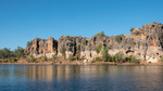
In contrast to yesterday today was a very short drive, less than 100 km, into Fitzroy Crossing and then north about 20km to a small National Park containing Geike Gorge. The gorge is formed by the Fitzroy River cutting through the Napier Range. You might recall we visited another part of the Napier Range at Windjana where we saw lots of "freshies" and observed fruit bats trying to avoid those same crocs while taking a drink. At Geike we took a boat tour of the Gorge. The photos tell that story well.
...click/tap to read the full postTo Halls Creek (Caroline Pool, Western Australia)
Journal entry for Saturday 22nd Jun, 2019 (day 117, kms 312)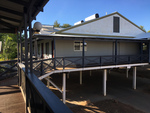
The main accommodation building at Fitzroy Crossing Lodge (photo 1) was quite interesting as the entire structure seems to be corrugated metal, and surrounds the swimming pool.
...click/tap to read the full postBungle Bungle (Bungle Bungle, Western Australia)
Journal entry for Sunday 23rd Jun, 2019 (day 118, kms 224)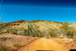
The access road to Purnululu National Park and the Bungle Bungle range is about 100km north of Halls Creek and it was an easy drive on paved road to that access road. From there to the Park Visitors Center is another 56km and we had heard all kinds of horror stories about how bad this twisty gravel road was. But to our surprise the road generally was in ok shape and had some very interesting scenery though we did not get any views of the Bungle Bungle Range at this time.
...click/tap to read the full postThe Bungles II (Bungle Bungle, Western Australia)
Journal entry for Monday 24th Jun, 2019 (day 119, kms 0)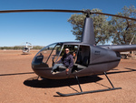
The main activity today was our 30 minute helicopter tour of the Bungle Range, and as with our previous heli tours we both were well satisfied with the experience. The ariel view gives an entirely different perspective. I won't make any other comment about the flight but rather let the photos tell the story.
...click/tap to read the full postThe Bungles III and Halls Creek (Halls Creek, Western Australia)
Journal entry for Tuesday 25th Jun, 2019 (day 120, kms 245)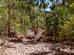
In her inimitable style Nina had another hike on the agenda this morning as a last taste of the Bungles before we made the trek back to Halls Creek. This one was called Echidna. We had no idea why that name was chosen, nor what we would see. The guide to the hike suggested there might be some climbing at the end of the hike but that was all. Unlike our earlier hikes this one was in the North West of the park so we could be certain that there would be no beehive domes.
...click/tap to read the full postTanami I (Wolfe Creek Crater, Western Australia)
Journal entry for Wednesday 26th Jun, 2019 (day 121, kms 150)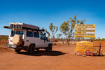
Today we started our traverse of the Tanami Road which will take us back to Alice Springs 1057 km from last nights camp at Halls Creek. Historically the Tanami Track (as it was called) was a cattle droving route along which pastoralists in the Kimberley moved their cattle to market. In the 1960s (after overland droving ceased, and there was no need to detour to find water for the cattle) the track was rerouted and shortened to approximately its current route. Today it is still a remote 80% gravel road that is almost devoid of services. At the North West end it starts 16km from Halls Creek (at a junction with the Great Northern Highway) and to the South Eastern end it joins the Stuart Highway 20km north of Alice.
...click/tap to read the full postTanami II (Tanami Road, Western Australia)
Journal entry for Thursday 27th Jun, 2019 (day 122, kms 294)
We made it to Billiluna this morning during their operating hours and bought 30.77 liters of fuel. Why such a strange amount? Well the rules for buying fuel at Billiluna are, you tell them how many liters you want, they will work out the price of that and round it to the nearest A$10, then give you a fuel card for that amount for which you must lodge a $5 deposit, you take the card out to the pump and dispense the fuel, then return the card and get your $5 deposit back. It turned out that 30.77 liters was almost too much I had to dribble the last 0.77 liters into both tanks to get it all in. But, non the less, we now definitely had enough fuel.
...click/tap to read the full postTanami III (Tanami Road, Western Australia)
Journal entry for Friday 28th Jun, 2019 (day 123, kms 392)
Another day, more kilometers, more red dust and surprisingly few additional creatures. We spotted the dingo at our morning tea break and the snake was crossing the road just a little later. The aeroplane needs some explanation. Roughly mid way along the Tanami Road there is a gold mine called the Granites Gold Mine run by Newmont Gold Mine. While passing this mine we spotted this passenger jet getting ready to takeoff. It was a little mind blowing. Here we are in what feels like the middle of nowhere and we see a jet plane just off to our left!
...click/tap to read the full postTanimi Fini (Alice Springs, Northern territory)
Journal entry for Saturday 29th Jun, 2019 (day 124, kms 256)This morning we knocked off the remaining 260kms into Alice Springs and thus brought our Tanami adventure to a true conclusion. When we fueled up in Alice we had travelled 1084 km since taking on fuel in Halls Creek. In addition to the 30.77L we got in Billiluna we added another 127.5L today in Alice for a total of 158.27L, so we could have made the entire distance without additional fuel. In addition to keeping track of fuel we also kept track of the other vehicles that we passed while we were driving. Over the 3 days prior to today we passed a total of 2 non-articulated trucks, 8 road trains, 34 pickups or SUVs pulling camping trailers or caravans, and 62 non towing pickups, or suvs or actual sedan cars. Since we drove for only 3-5 hours per day and did not count vehicles we saw while camped these numbers are well below the total number using the Tanami Road. The interesting thing is the mix, as well over half the non towing pickups/suvs were travelers like us with camping gear on board. The conclusion is that the vast majority of vehicles using the Tanami Road are doing so for recreational purposes. We find that interesting and entirely consistent with our less formal counts of vehicles we have encountered elsewhere on this trip.
...click/tap to read the full post