Posts From Australia
Day One (Herron Point, Western Australia, Australia)
Journal entry for Wednesday 27th Feb, 2019 (day 1, kms 92)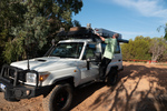
As arranged we were collected from out hotel at 9:00 am by a representative from WaExperts and delivered to their depot where we had a couple of hours training on the systems of the vehicle and then we were on our own.
...click/tap to read the full postTwenty Eights (Osmington, Western Australia, Australia)
Journal entry for Thursday 28th Feb, 2019 (day 2, kms 251)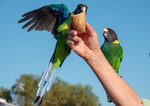
We spent a good deal of time this morning entertaining ourselves with the local parrots. We saw these guys yesterday afternoon but did not get a chance to feed/photograph them; made up for lost time this morning. After we had taken more than enough photos of these colorful little birds the camp host dropped by for a chat and during that chat informed us that the local name for this species of bird is twenty eights. Apparently this name originates from the fact that this species is 28th on the state list of vermin.
...click/tap to read the full postFiretail (Osmington, Western Australia, Australia)
Journal entry for Friday 1st Mar, 2019 (day 3, kms 156)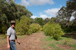
A Firetail is a bird that is indigenous to the Margaret River area of Western Australia and it is also the name of a small winery close by and recommended by our friend Richard. We started our day with a stop there and had quite a chat with owners Rob and Jess. Oh we also tasted some wine, bought some wine, and discovered that they keep a flock of guinea fowl as a way of controlling insect pests that would otherwise damage the grapes.
...click/tap to read the full postCape Leeuwin (Greens Island, Western Australia, Australia)
Journal entry for Saturday 2nd Mar, 2019 (day 4, kms 222)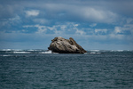
Today we visited Cape Leeuwin and its lighthouse (in the photos below) the most South Westerly point on the Australian continent and is also the junction of the Indian and Southern Oceans. Along the way we spent time visiting a number of remote beaches.
...click/tap to read the full postThe UPs (Crystal Springs, Western Australia, Australia)
Journal entry for Sunday 3rd Mar, 2019 (day 5, kms 277)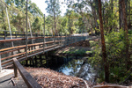
We started the day with a visit to Glenoran Pools and the One Tree Bridge, a bridge built by original settlers that consisted of a single tree felled across a river. Near the bridge is a stand of four Karri trees called the Four Acres which are quite spectacular but alas it does not seem possible to capture the grandeur in a photograph.
...click/tap to read the full postCoastal Attractions (Porongurup, Western Australia, Australia)
Journal entry for Tuesday 5th Mar, 2019 (day 7, kms 126)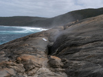
I forgot to mention in yesterdays post that places like our Panorama camp is typically called a Caravan Park in Australia and may have the phrase Tourist Park added in there somewhere. I also forgot to mention that there where two fifth wheels in the camp last night and both where being towed by Chevy Duramax Pickup trucks. I talked to one of the owners and discovered that GM Australia is now importing those trucks and performing the conversion to right hand drive for local consumption. It is also possible to buy Ford Super Duty and RAM Cummins pickup trucks but for these the right hand drive conversion is done after market not by the manufacturers.
...click/tap to read the full postGranite Skyway (Wave Rock, Western Australia, Australia)
Journal entry for Wednesday 6th Mar, 2019 (day 8, kms 311)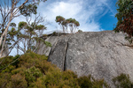
We started today with a 3 mile, 2000 ft climb, to The Granite Skyway. A steel walkway and observation platform that wraps around a large granite outcropping. After the 2000 ft climb, one must negotiate a rock scramble and then a 20 ft ladder to get to the walkway. The reward for this effort is great view of surrounding forest and farm land. As much as we enjoyed the experience we wondered whether the effort required to build the skyway was justified by the number of visitors.
...click/tap to read the full postOld lace (Coolgardie Western Australia, Australia)
Journal entry for Thursday 7th Mar, 2019 (day 9, kms 339)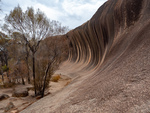
We started the day with the obligatory walk around and over Wave Rock, which was after all the point of coming to this place. I can see why some people described it to us as "under whelming" as it is not very high nor very long. But is interesting to discover how such a rock formation comes about. Its a result of differential erosion - different levels of soil moisture erodes the buried granite at different rates and soil moisture is at its highest somehwat below the surface (as surface moisture is evaporated by the sun). You will be pleased to know that there ends the days science lesson.
...click/tap to read the full postCoolgardie (Kalgoorlie, Western Australia, Australia)
Journal entry for Friday 8th Mar, 2019 (day 10, kms 63)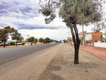
We did some historical research on the town of Coolgardie this morning. It was not difficult to do because the town has conveniently placed plaques at strategic locations that give visitors like us a glimpse into the hey-day of this now sleepy town. Coolgardie was the site of the original gold discovery that eventually gave rise to the mining operation at Kalgoorlie (25 miles away) which today is the largest open cut gold mine in the world. But initially the gold rush was sited in Coolgardie. At its peak the town sported two stock exchanges, 25 stock brokers, 26 hotels, 3 breweries, 7 news papers and 14 churches. Today Coolgardie is a sleepy town of 1200.
...click/tap to read the full postBeach driving (Esperance, Western Australia, Australia)
Journal entry for Sunday 10th Mar, 2019 (day 12, kms 334)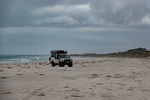
At the Tourist Information Center in Esperance this morning we discovered that Cape Arid National Park is closed indefinitely, and that all the camping grounds at Cape Le Grand are full and are booked out into the future. This disrupted our plans a bit as we had expected to spend the next couple of days exploring Cape Arid and to camp at Cape Le Grand. So after some replanning we spent the day touring the sights of the area, which are mostly beaches (hence the photos) and doing a little beach driving. This latter activity I saw as a good opportunity to get a sense of how our troopie will behave on the soft sand that we expect to find on some of the inland roads we plan to drive.
...click/tap to read the full postNon planning and grass trees (Alexander Bay, Western Australia, Australia)
Journal entry for Monday 11th Mar, 2019 (day 13, kms 126)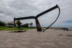
The first photo below is a representation of a whales tail one of the many attractions to be found on the foreshore of the town of Esperance (I should note that Esperance is a popular whale watching spot). The next few are scenes from the nearby Kepwari Wetland Trail. The dead trees are a result of deforestation of the area which causes the water table to rise and along with it salt which kills salt intolerant trees. Thereafter the day became a perfect example of how a plan can go completely out the window. As we started the day we both expected to head towards a place called Balladonia on the Erye Highway but after about 30 km we suddenly decided to give that idea a miss and see if we could find the vehicle track to Alexander Bay where there was apparently a beachside campground. So that became the new plan.
...click/tap to read the full postBack on the plan (Balladonia, Western Australia, Australia)
Journal entry for Tuesday 12th Mar, 2019 (day 14, kms 222)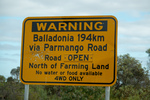
OK, so today we got back on the plan and headed for Balladonia. When originally planning this part of our trip we had expected to travel the Balladonia Track from Cape Arid National Park, but as I mentioned in an earlier post the park and that track are closed so we had to select an alternative route and that alternative was the Parmango Road, which as you can see is noted as a 4wd route only and also a route devoid of services for nealy 120 miles, and so it turned out. It tooks us nearly 6 hours to travers the 120 miles (4 hours driving and lots of stops), the first 45 miles were paved (though sometimes the paving was only wide enough for one vehicle), and much of the unpaved section was firm and often rock, making for easy driving but there were definietly a few sections of very soft sand/dust that could have been a problem for 2wd low clearance vehicles. Had the road been wet or had the weather been raining the story could have been very different. There were very long sections of clay with deep troughs from previous wet weather travels still visible.
...click/tap to read the full post