Posts From South Australia
The Nullarbor (West of Yalata, South Australia)
Journal entry for Saturday 16th Mar, 2019 (day 18, kms 313)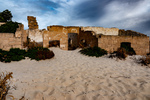
Before hitting the road today we drove a rough track from Eucla Roadhouse to the nearby coast to get a look at the remains of one of the early Eucla telegraph stations which is now partly devoured by the shifting dunes. Thereafter as we traveled east we visited a number of lookouts perched on the edge of the Bunda Cliffs (the sea cliffs that mark the eastern end of the Greast Australian Bight). At one of these lookouts we happened upon the same group of cyclists we passed yesterday and spent sometime chatting with them while they fueled up on some (high energy ?) food.
...click/tap to read the full postSand dunes and squid (Ceduna, South Australia)
Journal entry for Sunday 17th Mar, 2019 (day 19, kms 230)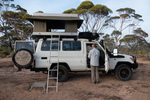
On waking this morning we were surprised to see a light fog and to find all the camping gear we left outside during the night wet from the mist. We thought this was a dry part of the world. I noted last night that we were camped in a eucalypt forest where many of the trees had multiple trunks sprouting from the same base and I thought that this type of eucalypt was called mallee. Later in the day I got a chance to google it and discovered that such trees are called mallee and they grow from an underground lignotuber.
...click/tap to read the full postA Day of Bays (Venus Bay, South Australia)
Journal entry for Monday 18th Mar, 2019 (day 20, kms 283)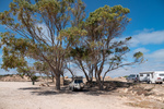
Smokey Bay, Streaky Bay (Hotel), a few rugged coastal cliffs, Venus Bay and throw in the sea lions of Point Labatt and in brief that captures today. What's missing from that brief narrative is just how beautiful todays stretch of coast is and how sparcely populated. The country side is mostly grain or sheep farming country with farm land abutting the coast, with scattered small communities every 60 miles or so. Smokey Bay was one of the smaller communities we passed through today (photo 4), it consists of maybe 2 dozen buildings only.
...click/tap to read the full postOut fishing early (Port Lincoln, South Australia)
Journal entry for Tuesday 19th Mar, 2019 (day 21, kms 360)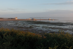
The Eyre Peninsula is at the western end of South Australias time zone so sunrise is around 8:00am at this time of year. However for the guests at the Venus Bay Caravan Park darkness did not prevent an early start on the important business of the days fishing. So by the time there was enough light for a photograph many of those tinnies had alrerady been launched at the local natural sand boat ramp and we only got photos of the late comers.
...click/tap to read the full postA Day in Port Lincoln (Port Lincoln, South Australia)
Journal entry for Wednesday 20th Mar, 2019 (day 22, kms 0)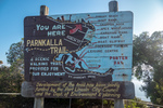
Port Lincoln might be described as a small city, but a large town is probably a more accurate description. Situated on beautiful Boston Bay it is (by South Australia standards) a large grain port with a very large grain storage complex and ship loading facility as its reason d'entre. The town was founded in 1839 because of its very large protected harbor (3 times the size of Sydney Harbor) and is now the regional center for the Eyre Peninsula.
...click/tap to read the full postAnimal Farm (Cleve, South Australia)
Journal entry for Thursday 21st Mar, 2019 (day 23, kms 116)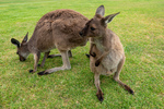
Regular readers of this blog will probably have already deduced that Nina and I like photographing animals/birds, so this morning we could not resist the opportunity to visit Glen Forest Animal Park a short drive from Port Lincoln. It is a bit corny going to such a place but on the other hand if did give us a chance to capture a number of iconic Australian animals.
...click/tap to read the full postIron Knob (Whyalla, South Australia)
Journal entry for Friday 22nd Mar, 2019 (day 24, kms 245)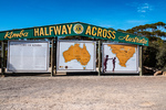
The goal for today was to make it to Whyalla, a largish town almost at the head of Spensers Gulf. Along the way we visited the town of Kimba whose claim to fame, is that it is half way across Australia (from east to west), and that it is the home of the Big Galah. On a nearby hill we also found metal statues of John Eyre (the first European to cross the continent of Australia from Sydney to "Perth") and his aboriginal companion Wylie.
...click/tap to read the full postFuel Filter (Lawrie Park, South Australia)
Journal entry for Saturday 23rd Mar, 2019 (day 25, kms 168)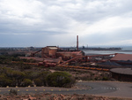
We did a driving tour of Whyalla this morning before hitting the road. From the Lookout on Hummock Hill the scope of the various industrial areas was apparent. This must have been quite an operation in its day.
...click/tap to read the full postNostalgia (Wallaroo, South Australia)
Journal entry for Sunday 24th Mar, 2019 (day 26, kms 149)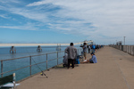
Today was to be a nostalgic day for me as our destination was the small beach town of Wallaroo. This was my mothers home town and the place I spent my first 10-11 years. Wallaroo's original reason for existence was as a copper mining and copper smelting town and in my childhood the old smelter works and the piles of cinders from the defunct smelting operation were great play grounds. After the copper era ended the Adelaide and Wallaroo Fertilizer Company produced agricultural fertilizer from imported fertilizer rock. The piles of ferilizer and rock were also a playground for us kids.
...click/tap to read the full postYorke Peninsula (Minlaton, South Australia)
Journal entry for Monday 25th Mar, 2019 (day 27, kms 187)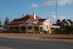
Today started with a visit to Wallaroo Museum and a walk around the town to see if my memory could match the geography and I could find my old elementary school. The museum visit was particularly satisfying because I found a series of photos that allowed me to match up my memories of the beach front area with that areas current arrangement. And I found an old building that is still part of an active elementary school that I recognized as my old class room. So I counted the morning a success.
...click/tap to read the full postStump Jump (Wallaroo, South Australia)
Journal entry for Tuesday 26th Mar, 2019 (day 28, kms 145)
We continued our shortened exploration of the Yorke Peninsula today with a visit to a few of the small seaside towns on the eastern shore of the peninsula and saw more great beaches, jetties and well maintained small towns. If one wanted a beachfront lifestyle, largely devoid of other people the Yorke (and Eyre) peninsulas would be good places to consider. At the town of Ardrossan we came across a Museum that featured the Stump Jump Plough, ... a what you might ask (see below).
...click/tap to read the full postAnother Toyota Dealer (Port Wakefield, South Australia)
Journal entry for Wednesday 27th Mar, 2019 (day 27, kms 81)
We spent the morning walking part of Wallaroo's Tourist Drive and capturing a few more photos of my "home town"; I now surely have enough to satisfy my nostalgia.
...click/tap to read the full postVictor Harbor (Victor Harbor, South Australia)
Journal entry for Thursday 28th Mar, 2019 (day 28, kms 195)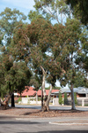
Victor Harbor is South along the coast from Adelaide, it is the major town in a large wetland area that constitutes the mouth of the Murray River (Australia's longest river), and that's where we ended today, a base for a couple of days exploring the area.
...click/tap to read the full postWet and windy (Cape Jervis, South Australia)
Journal entry for Friday 29th Mar, 2019 (day 29, kms 77)
We put a bit of effort into doing some sightseeing around Victor Harbor today but really the weather was against us. So around midday we headed for Cape Jervis (about 50 km away) where we decided to spend the night so that we would be close to the ferry to Kangaroo Island which we have to catch tomorrow morning at 8:30.
...click/tap to read the full postKI and interesting facts (Cape Jervis, South Australia)
Journal entry for Saturday 30th Mar, 2019 (day 30, kms 0)
As I mentioned in yesterdays post, this morning we were off to Kangaroo Island on the 8:30 ferry. What I did not mention was that we had booked to pick up a day long bus tour once off the ferry. The hope was that the bus tour would give us an overview of Kangaroo Island since we did not have the time in our schedule to spend days touring by ourselves.
...click/tap to read the full postThe Coorong (Goolwa, South Australia)
Journal entry for Sunday 31st Mar, 2019 (day 31, kms 86)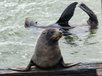
The reason we came to this part of the country was to see an area called the The Coorong. For us (particularly Nina) the Coorong has a couple of attractions or at least points of interest. Firstly it is the setting for a famous Australian story and film called Storm Boy and secondly it is the point at which Australia's biggest river system (The Murray Darling) empties into the ocean. The Coorong is an extensive tidal estuarial region that encompasses the mouth of the Murray River.
...click/tap to read the full postBusiness and Catchup (Adelaide, South Australia)
Journal entry for Wednesday 3rd Apr, 2019 (day 36, kms 47)
We spent the nights of April 1st, 2nd, 3rd in Adelaide primariliy for the purpose of "business" (more vehicle work and completing US tax returns) rather than sight seeing. Never the less we took the opportunity to renew our aquaintence with Adelaide city/downtown and the area around the Torrens River. The Adelaide metro area has grown dramatically since our last visit over 20 years ago and is quite a sprawl. The city and Torrens area have undergone some major upgrades but has retained the charm of the city we knew.
...click/tap to read the full postBurra Burra (Hallett, South Australia)
Journal entry for Thursday 4th Apr, 2019 (day 37, kms 209)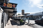
We spent the morning navigating our way through the northern sprawl of the Adelaide metro area, passing through the township of Elizabeth, which was once a major car manufacturing center for GM when it was still building the Australian car the Holden.
...click/tap to read the full postWeird Signs and Other Trivia (Hawker, South Australia)
Journal entry for Friday 5th Apr, 2019 (day 38, kms 201)
The pictures in this post start with a few of the interestng signs we encountered during the day. The first of the signs is self explanatory, it just struck us as pretty typical Australian - anything with beer in it.
...click/tap to read the full postGorges of the Flinders (Flinders Rangers, South Australia)
Journal entry for Saturday 6th Apr, 2019 (day 39, kms 177)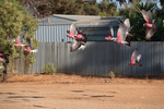
The cockatoos were out and about while we were fueling up in Hawker this morning and Nina managed to capture a flock of them in flight. There after, as you can see from the rest of the photos, we spent the day sightseeing by following a series of rough unpaved scenic roads or tracks through gorges or steep sided creek valleys. Morolana Road, Brachina Gorge and Bunyeroo Gorge. We found these gorges quite fascinating. In this incedibly dry country where most of the vegetation is low scrub, the creeks are an avenue of very large River Gum trees.These trees survive in this place by driving their roots down hundreds of feet to find the creeks water that is often still flowing underground.
...click/tap to read the full postChambers Gorge (Chambers Gorge, South Australia)
Journal entry for Sunday 7th Apr, 2019 (day 40, kms 192)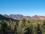
Today was intended to be a bit of nostalgia, we planned on camping the night in a place named Chambers Gorge, it is an informal camping area on private property that is somewhat off the beaten track and being "informal" has no facilities at all. The nostalgia relates to the fact that we camped in this place in 1997 when on an outback trip with our then young children and we remember this place with some fondness.
...click/tap to read the full postFlies (Arkaroola, South Australia)
Journal entry for Monday 8th Apr, 2019 (day 41, kms 112)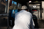
As you can see the flies were back this morning as soon as the sun appeared; this prompted us to get moving and keep moving. The second photograph are the signs at the junction of two gravel roads; the view was the same in every direction. It is amazing even to us how empty this place can sometimes feel; in todays driving we passed 3 other vehicles and one of those was a road grader.
...click/tap to read the full postSome 4LOW (Leigh Creek, South Australia)
Journal entry for Tuesday 9th Apr, 2019 (day 42, kms 191)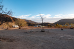
This morning we retraced yesterday afternoons route to the Bolla Bollana Smelter ruins and there after a series of 4wd tracks south through part of the Gammon Ranges National Park. Again this was a nostalga exercise reliving past adventures. It was also the first time on this journey where there was any substantial need for 4wd low range as there were some steep rock climbs and descents. The descent to the abandoned Idninha out station building was probably the most demanding.
...click/tap to read the full postFirst flat and Aussie Icon (Marree, South Australia)
Journal entry for Wednesday 10th Apr, 2019 (day 43, kms 133)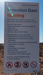
We got going early this morning wanting to be at the Leigh Creek gas station at 8:00 (its opening time) to get the flat tire fixed. However Leigh Creek does not fix tires, I was directed 5 km up the road to Copley where the task was completed promptly. More evidence for me that Copley will eventually win out as the tourist stop on this part of the trek.
...click/tap to read the full postA Technological History (Roxby Downs, South Australia)
Journal entry for Thursday 11th Apr, 2019 (day 45, kms 275)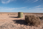
Yesterday while planning our current little side trip I wondered about the name of the Borefield Road but this mornings drive south towards Roxby Downs answered at least part of my question. The road was lined with capped bores (spear point wells down to the artesian water table) with periodic larger structures including filling stations for water tankers.
...click/tap to read the full postLake Eyre (Haligan Bay, South Australia)
Journal entry for Friday 12th Apr, 2019 (day 46, kms 313)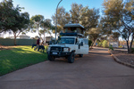
We spent the morning retracing our route of yesterday along the Bore Field Road and then rejoined the Oodnadatta Track. Along the track we stopped at a few points of interest, either old railway sidings (with ruins of railway buildings, broken bore machinery and in one case an old cast iron water tank) or natural springs. This part of inland Australia sits on top of the Great Artisian Basin, a large underground water deposit that covers 22% of Australias area and is estimated to hold 15,600 cubic miles of water. Along the Oodnadatta Track this water comes to the surface in natural springs in mound formations and provided natural staging places for early settlers and the early railways.
...click/tap to read the full postCadibarrawirracanna (Coober Pedy, South Australia)
Journal entry for Saturday 13th Apr, 2019 (day 47, kms 222)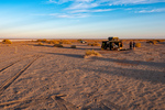
The first stop after leaving Lake Eyre this morning was the village/roadhouse of William Creek which consists of a pub, a scenic flight business in a single building, a bush campground and a gas station attached to the pub. One of our guide books described it as an iconic outback pub, it certainly is an interesting building. Seems to be mostly built from railway sleepers. Perhaps the most interesting thing about William Creek is that it is located on Anna Creek Station the largest cattle station (ranch) in the world. At 9142 sq miles it is just a little bit bigger than the country of Israel. The station was originally established by Sidney Kidman who realized that the only way to run cattle successfully in the Australian outback was to have a very low ratio of cattle to land. ß
...click/tap to read the full postNight on a cattle station (Arckaringa, South Australia)
Journal entry for Sunday 14th Apr, 2019 (day 48, kms 159)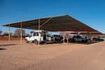
It took us a little while to get ourselves out of Coober Pedy this morning. What with queuing up to buy fresh drinking water, buying a new gas stove, Nina's 10,000 steps and my mandatory cafe visit for a coffee we did not even get to the underground museum and mine until 10:00am. The museum was pretty good and of course depicted the story of opal discovery and the development of mining in this region. Like a lot of pioneer stories the beginning of opal mining at the Coober Pedy location is a tale of determination bordering on crazyness. After the initial discovery two men arrived at the site with 100 gallons of water on a bullock dray and stayed mining until their water ran out. To extend their water they collected all used waste water in a drum and skimmed the "clean" water off the top. When that finally ran out they had to walk 90 miles to a nearby rail head. All this in a region that is recognized as the driest part of Australia, the driest continent on earth.
...click/tap to read the full postAlgebuckina Bridge (Oodnadatta, South Australia)
Journal entry for Monday 15th Apr, 2019 (day 49, kms 211)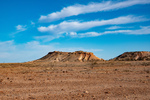
We discovered this morning that the family that manages Arckaringa are on vacation and the young man that arrived last night works for the company that owns the station (the same company owns an adjacent property). Our route this morning, as planned yesterday, took us through what is called the Painted Desert, an area of small mesas with multi-colored soil and rock layers from the variation of mineral content.
...click/tap to read the full postDalhousie Springs (3O'Clock Creek, South Australia)
Journal entry for Tuesday 16th Apr, 2019 (day 50, kms 190)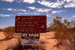
I have used the word "iconic" a number of times in recent posts and I am now regreting that as I want to use it again, to describe our destination for today. The place is called Dalhousie Springs and it is well known in Australia for a number of different reasons, perhaps the most common being the complex of hot thermal pools that make it a little oasis in the desert but also because it is the western entrance to the 4wd track across the Simpson Desert to Birdsville, one of the most famous outback 4wd trails. As you can see from the photo of the sign that track was now (or recently) closed due to of all things flood waters coming down from northern Australia.
...click/tap to read the full postBirdsville Track I (Mungerannie, South Australia)
Journal entry for Thursday 18th Apr, 2024 (day 20, kms 313)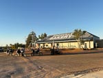
We started the day with a visit to Birdsville Bakery, just like a lot of other travellers. Thereafter we started the long trek down the legendary Birdsville Track to the town of Marree. The track was in much better condition than we had expected though there was a lot of small scale water damage with most of the small creek crossings being rough. There was also a lot of water still around in the paddocks beside the track and in ponds in the creeks. We only encountered maybe half a dozen pools actually on the track that we needed to cross.
...click/tap to read the full postBirdsville Track II (Lyndhusrt, South Australia)
Journal entry for Friday 19th Apr, 2024 (day 21, kms 286)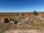
The notable feature of today is probably the flat tyre we had to deal with. We parked at the campground where the track crosses Cooper Creek and noticed the tyre was going down so was able to change it without driving on the flat tyre; fortunate as that saved us from destroying the tyre.
...click/tap to read the full postStrzelecki Part I (Somewhere on the Strzelecki Track, South Australia)
Journal entry for Saturday 20th Apr, 2024 (day 22, kms 315)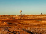
Before leaving Lyndhurst this morning Nina went on her usual morning walk and got captivated by thee effect of the early morning sun on the earth dams behind the hotel. The photos in some sad way captures the essense of Lyndhurst. A cross-road settlement that barely earns the title of a town and consists of two gas stations and a pub.
...click/tap to read the full post