Posts for March, 2019
Firetail (Osmington, Western Australia, Australia)
Journal entry for Friday 1st Mar, 2019 (day 3, kms 156)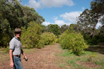
A Firetail is a bird that is indigenous to the Margaret River area of Western Australia and it is also the name of a small winery close by and recommended by our friend Richard. We started our day with a stop there and had quite a chat with owners Rob and Jess. Oh we also tasted some wine, bought some wine, and discovered that they keep a flock of guinea fowl as a way of controlling insect pests that would otherwise damage the grapes.
...click/tap to read the full postCape Leeuwin (Greens Island, Western Australia, Australia)
Journal entry for Saturday 2nd Mar, 2019 (day 4, kms 222)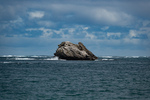
Today we visited Cape Leeuwin and its lighthouse (in the photos below) the most South Westerly point on the Australian continent and is also the junction of the Indian and Southern Oceans. Along the way we spent time visiting a number of remote beaches.
...click/tap to read the full postThe UPs (Crystal Springs, Western Australia, Australia)
Journal entry for Sunday 3rd Mar, 2019 (day 5, kms 277)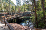
We started the day with a visit to Glenoran Pools and the One Tree Bridge, a bridge built by original settlers that consisted of a single tree felled across a river. Near the bridge is a stand of four Karri trees called the Four Acres which are quite spectacular but alas it does not seem possible to capture the grandeur in a photograph.
...click/tap to read the full postTingle (Albany, Western Australia)
Journal entry for Monday 4th Mar, 2019 (day 6, kms 173)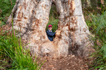
Today was about Tingle trees, another form of eucalyptus that is unique to South West Western Australia. There are three forms of this tree, Red Tingle, Yellow Tingle (named after the color of the wood) and Rake Tingle, named after the person who recognized that there was a third form. Like all Eucalypts Tingles are hard wood. The word Tingle is the aboriginal name.
...click/tap to read the full postCoastal Attractions (Porongurup, Western Australia, Australia)
Journal entry for Tuesday 5th Mar, 2019 (day 7, kms 126)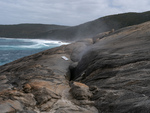
I forgot to mention in yesterdays post that places like our Panorama camp is typically called a Caravan Park in Australia and may have the phrase Tourist Park added in there somewhere. I also forgot to mention that there where two fifth wheels in the camp last night and both where being towed by Chevy Duramax Pickup trucks. I talked to one of the owners and discovered that GM Australia is now importing those trucks and performing the conversion to right hand drive for local consumption. It is also possible to buy Ford Super Duty and RAM Cummins pickup trucks but for these the right hand drive conversion is done after market not by the manufacturers.
...click/tap to read the full postGranite Skyway (Wave Rock, Western Australia, Australia)
Journal entry for Wednesday 6th Mar, 2019 (day 8, kms 311)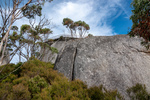
We started today with a 3 mile, 2000 ft climb, to The Granite Skyway. A steel walkway and observation platform that wraps around a large granite outcropping. After the 2000 ft climb, one must negotiate a rock scramble and then a 20 ft ladder to get to the walkway. The reward for this effort is great view of surrounding forest and farm land. As much as we enjoyed the experience we wondered whether the effort required to build the skyway was justified by the number of visitors.
...click/tap to read the full postOld lace (Coolgardie Western Australia, Australia)
Journal entry for Thursday 7th Mar, 2019 (day 9, kms 339)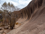
We started the day with the obligatory walk around and over Wave Rock, which was after all the point of coming to this place. I can see why some people described it to us as "under whelming" as it is not very high nor very long. But is interesting to discover how such a rock formation comes about. Its a result of differential erosion - different levels of soil moisture erodes the buried granite at different rates and soil moisture is at its highest somehwat below the surface (as surface moisture is evaporated by the sun). You will be pleased to know that there ends the days science lesson.
...click/tap to read the full postCoolgardie (Kalgoorlie, Western Australia, Australia)
Journal entry for Friday 8th Mar, 2019 (day 10, kms 63)
We did some historical research on the town of Coolgardie this morning. It was not difficult to do because the town has conveniently placed plaques at strategic locations that give visitors like us a glimpse into the hey-day of this now sleepy town. Coolgardie was the site of the original gold discovery that eventually gave rise to the mining operation at Kalgoorlie (25 miles away) which today is the largest open cut gold mine in the world. But initially the gold rush was sited in Coolgardie. At its peak the town sported two stock exchanges, 25 stock brokers, 26 hotels, 3 breweries, 7 news papers and 14 churches. Today Coolgardie is a sleepy town of 1200.
...click/tap to read the full postSuper Pit (Kumarl Rest Stop, A Country)
Journal entry for Saturday 9th Mar, 2019 (day 11, kms 254)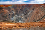
The Super Pit is the name given to the open-cut gold mine that is the economic reason for the existence of Kalgoorlie. The statistics of this mine are truily impressive. The open cut pit is 3.5km long by 1.5 km wide by 750 meters deep (in US measures that is 2.1 miles x 1 mile x 2500 ft. Gold bearing ore is brought from the bottom of this pit in trucks that carry about 230 tons per load, each trip uses about 50 gallons of diesel fuel and the mine in total uses between 6,000,000 and 7,000,000 liters of diesel per month (thats 1.5 to 1.75 millions gallons per month). A tour of this operation has been on our Australian todo-list almost since the start of our planning and today was the day.
...click/tap to read the full postBeach driving (Esperance, Western Australia, Australia)
Journal entry for Sunday 10th Mar, 2019 (day 12, kms 334)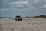
At the Tourist Information Center in Esperance this morning we discovered that Cape Arid National Park is closed indefinitely, and that all the camping grounds at Cape Le Grand are full and are booked out into the future. This disrupted our plans a bit as we had expected to spend the next couple of days exploring Cape Arid and to camp at Cape Le Grand. So after some replanning we spent the day touring the sights of the area, which are mostly beaches (hence the photos) and doing a little beach driving. This latter activity I saw as a good opportunity to get a sense of how our troopie will behave on the soft sand that we expect to find on some of the inland roads we plan to drive.
...click/tap to read the full postNon planning and grass trees (Alexander Bay, Western Australia, Australia)
Journal entry for Monday 11th Mar, 2019 (day 13, kms 126)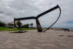
The first photo below is a representation of a whales tail one of the many attractions to be found on the foreshore of the town of Esperance (I should note that Esperance is a popular whale watching spot). The next few are scenes from the nearby Kepwari Wetland Trail. The dead trees are a result of deforestation of the area which causes the water table to rise and along with it salt which kills salt intolerant trees. Thereafter the day became a perfect example of how a plan can go completely out the window. As we started the day we both expected to head towards a place called Balladonia on the Erye Highway but after about 30 km we suddenly decided to give that idea a miss and see if we could find the vehicle track to Alexander Bay where there was apparently a beachside campground. So that became the new plan.
...click/tap to read the full postBack on the plan (Balladonia, Western Australia, Australia)
Journal entry for Tuesday 12th Mar, 2019 (day 14, kms 222)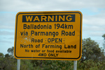
OK, so today we got back on the plan and headed for Balladonia. When originally planning this part of our trip we had expected to travel the Balladonia Track from Cape Arid National Park, but as I mentioned in an earlier post the park and that track are closed so we had to select an alternative route and that alternative was the Parmango Road, which as you can see is noted as a 4wd route only and also a route devoid of services for nealy 120 miles, and so it turned out. It tooks us nearly 6 hours to travers the 120 miles (4 hours driving and lots of stops), the first 45 miles were paved (though sometimes the paving was only wide enough for one vehicle), and much of the unpaved section was firm and often rock, making for easy driving but there were definietly a few sections of very soft sand/dust that could have been a problem for 2wd low clearance vehicles. Had the road been wet or had the weather been raining the story could have been very different. There were very long sections of clay with deep troughs from previous wet weather travels still visible.
...click/tap to read the full postBaxter Cliffs (Baxter Cliffs, Western Australia)
Journal entry for Wednesday 13th Mar, 2019 (day 15, kms 182)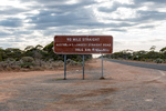
The sign shown in the first photo below is encountered a little way East of Balladonia, and as advertised for the next 90 miles, all the way to the road house at Caiguna, the road is absolutely straight. A little while with google will soon determine that this is NOT the longest straight section of road in the world, that title belongs to a section of road in Saudi Arabia that is 60 miles (approx) longer. It is worth noting however that the railway line from Perth to South Australia does have the longest straight section of rail line in the world at 478 km (298 miles).
...click/tap to read the full postThe Eyre Bird Observatory (Eyre Highway, Western Australia)
Journal entry for Thursday 14th Mar, 2019 (day 16, kms 232)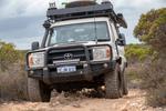
Our day started with a retracing of the Baxter Cliffs route back to Caiguna Roadhouse; no navigation issues this time. A bit less than an hour East of Caiguna we found Cocklebiddy Road house and got some details of the route to the Eyre Bird Observatory (see below for a few details).
...click/tap to read the full postYour next golfing holiday (Eucla, Western Austrtlia)
Journal entry for Friday 15th Mar, 2019 (day 17, kms 255)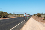
Try the Nullarbor Golf Links for your next golfing holiday. The course stretches the 1365 kms of the Eyre Highway between Kalgoorlie Western Australia and Ceduna South Australia. Each hole is located at one of the towns or road houses along the way. We decided to provide a few photos of the course so that our friends who are keen golfers can accurately assess the course conditions before buying plane tickets to Kalgoorlie.
...click/tap to read the full postThe Nullarbor (West of Yalata, South Australia)
Journal entry for Saturday 16th Mar, 2019 (day 18, kms 313)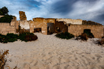
Before hitting the road today we drove a rough track from Eucla Roadhouse to the nearby coast to get a look at the remains of one of the early Eucla telegraph stations which is now partly devoured by the shifting dunes. Thereafter as we traveled east we visited a number of lookouts perched on the edge of the Bunda Cliffs (the sea cliffs that mark the eastern end of the Greast Australian Bight). At one of these lookouts we happened upon the same group of cyclists we passed yesterday and spent sometime chatting with them while they fueled up on some (high energy ?) food.
...click/tap to read the full postSand dunes and squid (Ceduna, South Australia)
Journal entry for Sunday 17th Mar, 2019 (day 19, kms 230)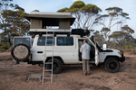
On waking this morning we were surprised to see a light fog and to find all the camping gear we left outside during the night wet from the mist. We thought this was a dry part of the world. I noted last night that we were camped in a eucalypt forest where many of the trees had multiple trunks sprouting from the same base and I thought that this type of eucalypt was called mallee. Later in the day I got a chance to google it and discovered that such trees are called mallee and they grow from an underground lignotuber.
...click/tap to read the full postA Day of Bays (Venus Bay, South Australia)
Journal entry for Monday 18th Mar, 2019 (day 20, kms 283)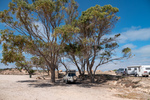
Smokey Bay, Streaky Bay (Hotel), a few rugged coastal cliffs, Venus Bay and throw in the sea lions of Point Labatt and in brief that captures today. What's missing from that brief narrative is just how beautiful todays stretch of coast is and how sparcely populated. The country side is mostly grain or sheep farming country with farm land abutting the coast, with scattered small communities every 60 miles or so. Smokey Bay was one of the smaller communities we passed through today (photo 4), it consists of maybe 2 dozen buildings only.
...click/tap to read the full postOut fishing early (Port Lincoln, South Australia)
Journal entry for Tuesday 19th Mar, 2019 (day 21, kms 360)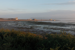
The Eyre Peninsula is at the western end of South Australias time zone so sunrise is around 8:00am at this time of year. However for the guests at the Venus Bay Caravan Park darkness did not prevent an early start on the important business of the days fishing. So by the time there was enough light for a photograph many of those tinnies had alrerady been launched at the local natural sand boat ramp and we only got photos of the late comers.
...click/tap to read the full postA Day in Port Lincoln (Port Lincoln, South Australia)
Journal entry for Wednesday 20th Mar, 2019 (day 22, kms 0)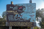
Port Lincoln might be described as a small city, but a large town is probably a more accurate description. Situated on beautiful Boston Bay it is (by South Australia standards) a large grain port with a very large grain storage complex and ship loading facility as its reason d'entre. The town was founded in 1839 because of its very large protected harbor (3 times the size of Sydney Harbor) and is now the regional center for the Eyre Peninsula.
...click/tap to read the full postAnimal Farm (Cleve, South Australia)
Journal entry for Thursday 21st Mar, 2019 (day 23, kms 116)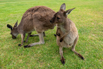
Regular readers of this blog will probably have already deduced that Nina and I like photographing animals/birds, so this morning we could not resist the opportunity to visit Glen Forest Animal Park a short drive from Port Lincoln. It is a bit corny going to such a place but on the other hand if did give us a chance to capture a number of iconic Australian animals.
...click/tap to read the full postIron Knob (Whyalla, South Australia)
Journal entry for Friday 22nd Mar, 2019 (day 24, kms 245)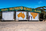
The goal for today was to make it to Whyalla, a largish town almost at the head of Spensers Gulf. Along the way we visited the town of Kimba whose claim to fame, is that it is half way across Australia (from east to west), and that it is the home of the Big Galah. On a nearby hill we also found metal statues of John Eyre (the first European to cross the continent of Australia from Sydney to "Perth") and his aboriginal companion Wylie.
...click/tap to read the full postFuel Filter (Lawrie Park, South Australia)
Journal entry for Saturday 23rd Mar, 2019 (day 25, kms 168)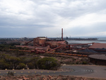
We did a driving tour of Whyalla this morning before hitting the road. From the Lookout on Hummock Hill the scope of the various industrial areas was apparent. This must have been quite an operation in its day.
...click/tap to read the full postNostalgia (Wallaroo, South Australia)
Journal entry for Sunday 24th Mar, 2019 (day 26, kms 149)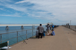
Today was to be a nostalgic day for me as our destination was the small beach town of Wallaroo. This was my mothers home town and the place I spent my first 10-11 years. Wallaroo's original reason for existence was as a copper mining and copper smelting town and in my childhood the old smelter works and the piles of cinders from the defunct smelting operation were great play grounds. After the copper era ended the Adelaide and Wallaroo Fertilizer Company produced agricultural fertilizer from imported fertilizer rock. The piles of ferilizer and rock were also a playground for us kids.
...click/tap to read the full postYorke Peninsula (Minlaton, South Australia)
Journal entry for Monday 25th Mar, 2019 (day 27, kms 187)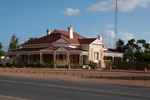
Today started with a visit to Wallaroo Museum and a walk around the town to see if my memory could match the geography and I could find my old elementary school. The museum visit was particularly satisfying because I found a series of photos that allowed me to match up my memories of the beach front area with that areas current arrangement. And I found an old building that is still part of an active elementary school that I recognized as my old class room. So I counted the morning a success.
...click/tap to read the full postStump Jump (Wallaroo, South Australia)
Journal entry for Tuesday 26th Mar, 2019 (day 28, kms 145)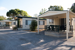
We continued our shortened exploration of the Yorke Peninsula today with a visit to a few of the small seaside towns on the eastern shore of the peninsula and saw more great beaches, jetties and well maintained small towns. If one wanted a beachfront lifestyle, largely devoid of other people the Yorke (and Eyre) peninsulas would be good places to consider. At the town of Ardrossan we came across a Museum that featured the Stump Jump Plough, ... a what you might ask (see below).
...click/tap to read the full postAnother Toyota Dealer (Port Wakefield, South Australia)
Journal entry for Wednesday 27th Mar, 2019 (day 27, kms 81)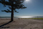
We spent the morning walking part of Wallaroo's Tourist Drive and capturing a few more photos of my "home town"; I now surely have enough to satisfy my nostalgia.
...click/tap to read the full postVictor Harbor (Victor Harbor, South Australia)
Journal entry for Thursday 28th Mar, 2019 (day 28, kms 195)
Victor Harbor is South along the coast from Adelaide, it is the major town in a large wetland area that constitutes the mouth of the Murray River (Australia's longest river), and that's where we ended today, a base for a couple of days exploring the area.
...click/tap to read the full postWet and windy (Cape Jervis, South Australia)
Journal entry for Friday 29th Mar, 2019 (day 29, kms 77)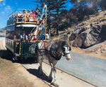
We put a bit of effort into doing some sightseeing around Victor Harbor today but really the weather was against us. So around midday we headed for Cape Jervis (about 50 km away) where we decided to spend the night so that we would be close to the ferry to Kangaroo Island which we have to catch tomorrow morning at 8:30.
...click/tap to read the full postKI and interesting facts (Cape Jervis, South Australia)
Journal entry for Saturday 30th Mar, 2019 (day 30, kms 0)
As I mentioned in yesterdays post, this morning we were off to Kangaroo Island on the 8:30 ferry. What I did not mention was that we had booked to pick up a day long bus tour once off the ferry. The hope was that the bus tour would give us an overview of Kangaroo Island since we did not have the time in our schedule to spend days touring by ourselves.
...click/tap to read the full postThe Coorong (Goolwa, South Australia)
Journal entry for Sunday 31st Mar, 2019 (day 31, kms 86)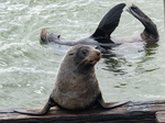
The reason we came to this part of the country was to see an area called the The Coorong. For us (particularly Nina) the Coorong has a couple of attractions or at least points of interest. Firstly it is the setting for a famous Australian story and film called Storm Boy and secondly it is the point at which Australia's biggest river system (The Murray Darling) empties into the ocean. The Coorong is an extensive tidal estuarial region that encompasses the mouth of the Murray River.
...click/tap to read the full post