Posts for category camping
Not entirely solo (Nanaimo, Canada)
Journal entry for Saturday 23rd Jun, 2018 (day 1, miles 175)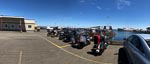
For the first two days of this adventure I am accompanied by a friend named Todd, so I have to admit that the journey is not entirely solo. But only a small cheat.
...click/tap to read the full postSea to Sky (Lillooet, Canada)
Journal entry for Sunday 24th Jun, 2018 (day 2, miles 323)
We were pleasantly surprised this morning to find that the campground had a cafe that opened at 8:00 so morning coffee was pretty easy to organize. So once fortified we packed and headed to the ferry terminal to await the loading of the vessel to Horse Shoe Bay. By the time loading started there were a large pack of bikes of all kinds most laden down with gear for an extended journey.
...click/tap to read the full postStorms shorten the day (100 Mile House, Canada)
Journal entry for Monday 25th Jun, 2018 (day 3, miles 446)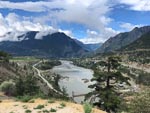
Highway 99 continued past Lillooet this morning and continued to be great riding and spectacular scenery; the weather even continued acceptable. At the intersection with Highway 12 is the town of Cache Creek and here I had breakfast before continuing north on 12. Soon the weather deteriorated with torrential rain, high wind and even hail.
...click/tap to read the full postRoadhouse philosophy (Prince George, Canada)
Journal entry for Tuesday 26th Jun, 2018 (day 4, miles 659)
Yesterdays storm was gone this morning to be replaced by crystal clear sky and bright sun which displayed the countryside wonderfully. However without the usual expedition photographer along on this journey the job of capturing the scenery and recording events fell to me. I just hope I am up to the task.
...click/tap to read the full postForest (Smithers, Canada)
Journal entry for Wednesday 27th Jun, 2018 (day 5, miles 893)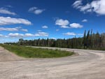
Today my route took me West along Highway 16 a somewhat less busy road than Highway 97 of the previous couple of days. The weather continued generally fine but with a strong buffeting wind that made riding a little less pleasant than normal.
...click/tap to read the full postLeaving civilization - sort of (Bell 2, Canada)
Journal entry for Thursday 28th Jun, 2018 (day 6, miles 1,118)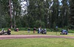
The Yukon (Boya Lake Provincial Park, Canada)
Journal entry for Friday 29th Jun, 2018 (day 7, miles 1,358)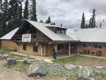
Heading North this morning from Bell 2 was more of the mountains, forests, good lonely road of yesterday. Though a little spice was added by patchy rain showers that sometimes were quite heavy. The rain slowed me down some what as I am still a bit of a novice to this motorcycle stuff and I don't want to misjudge a corner in the wet. Late morning, some what before Dease Lake I called into Tatogga Lake Resort a campground and restaurant housed in a quaint log building where I had breakfast (or as it is becoming the days main meal).
...click/tap to read the full postThe Alaska Highway (Alcan) (Squanga Lake Territorial Park, Canada)
Journal entry for Saturday 30th Jun, 2018 (day 8, miles 1,627)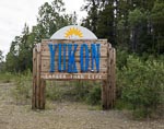
The first phase of todays journey was to complete the crossing of British Columbia and arrive at the border with the Yukon Territory. The effort required to cross BC from South to North never ceases to amaze me, and this trip is no exception. At the Yukon border sign the odometer on the bike is showing 30584 miles or 1300 miles since the ferry from port Angeles first dropped me on BC soil. A few more miles and the Cassiar Highway was done and I have arrived at the Alaska Highway.
...click/tap to read the full postYukon Rivers (Moose Creek, Canada)
Journal entry for Tuesday 3rd Jul, 2018 (day 11, miles 1,932)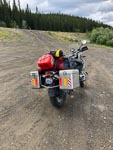
I dithered about in Whitehorse a bit this morning before getting underway. I had to buy one of those red plastic fuel containers and then figure out how to attach it to the bike. I had expected to get a 2 gallon container but of course I should have realized all containers here would be metric so the choice was 5 liters (1.25 gals) or 10 liters (2.5 gals). After way too much deliberation I went with the 10 liter variety. Strapping it to the bike required a set of 4 lime green tie-down straps 3 of which were surplus to requirements; thus my load of unnecessary items is increased.
...click/tap to read the full postGlorious Day (Eagle Plains, Canada)
Journal entry for Wednesday 4th Jul, 2018 (day 12, miles 2,278)
I could not get out of the campground fast enough this morning, I don't really like mosquitoes. Rather than hit the road I headed back towards Whitehorse about half a mile to Moose Creek Lodge for todays installment on the Traditional Yukon Breakfast; it also was good and too big. Thereafter I hit the road to Dawson City. The weather was glorious. Bright sun with temperatures sometimes in the high 70s. So I was keen to get to Dawson City to gas up and then head up the Dempster Highway with the hope of getting to Eagle Plains; the first fuel stop on the Dempster and about half way to Inuvik.
...click/tap to read the full postNot so Glorious (Eagle Plains, Canada)
Journal entry for Thursday 5th Jul, 2018 (day 13, miles 2,372)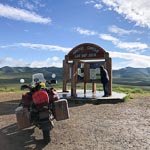
It was raining gently this morning as I pulled up to the gas pump to fill up for what I hoped would be a long day to Inuvik. I did not know it at the time but the guy that pumped the gas was prophetic as he said "you should not be going north in this weather". Yesterday was my introduction to gravel, today it was an introduction to mud. The first few miles were very tentative but within an hour the rain eased a bit and by the time I got to the rest area and monument for the Arctic Circle (25 miles from Eagle Plains) I was beginning to get hopeful.
...click/tap to read the full postRetreat (Dawson City, Canada)
Journal entry for Friday 6th Jul, 2018 (day 14, miles 2,621)
Today my retreat from Eagle Plains was mostly uneventful. There was a dense cloud cover with some mist in the valleys but fortunately no rain. The road was mostly dry so my gravel experience of two days ago was helpful. The cloud and consequence poor light rendered the scenery less of a post card and more of a bland grey mush. But as I have learned to do from other adventures I took the time to stop regularly to take a mental picture my surroundings. There is a good chance I will never be back to this place.
...click/tap to read the full postTop of the world (Tok, USA)
Journal entry for Saturday 7th Jul, 2018 (day 15, miles 2,807)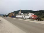
I spent a little time in the downtown area of Dawson City this morning, noting the touristification that has taken place since we were last here. Main Street is now looking pretty cute and up market but the "behind" streets are still pretty basic and unpaved.
...click/tap to read the full postWind (Fairbanks, USA)
Journal entry for Sunday 8th Jul, 2018 (day 16, miles 3,040)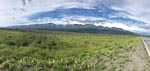
I thought today would be an easy 200 mile ride into Fairbanks. It started out warm though a bit windy and initially I spent time stopping to get some photos of The Alaskan Range. But as the day progressed the wind picked up and by late morning a howling wind (mostly a cross wind that demanded careful attention while riding), lots of dust turned the ride into a survival event.
...click/tap to read the full postThe Dalton (Coldfoot, USA)
Journal entry for Tuesday 10th Jul, 2018 (day 18, miles 3,290)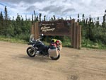
To get started on the Dalton Highway one has to drive (or in my case ride) about 80 miles along the Elliot Highway north from Fairbanks. The Elliot is reasonable quality paved country road so that 80 miles is no big deal, just a bit tedious, because one is keen to "get started" on the great adventure to Deadhorse.
...click/tap to read the full postTesing my limits (Deadhorse, USA)
Journal entry for Wednesday 11th Jul, 2018 (day 19, miles 3,525)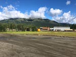
I felt very lucky this morning when I looked out on a bright sunny day. Maybe, I thought, I would have good weather all the way to Deadhorse. Yeh, right. But I was not to know the truth for a while. North from Coldfoot the road is paved for about 35 miles and one starts to get views of the Brooks Range even before the pavement ends. So note to future travelers. Go North of Coldfoot a bit as the road is paved for a while and the views are good (provided the weather is OK).
...click/tap to read the full postA relief, or good luck (Coldfoot, USA)
Journal entry for Thursday 12th Jul, 2018 (day 20, miles 3,770)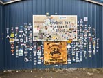
Last night at dinner I met a German guy who had flown in to Deadhorse with a bicycle in an airline box ready to start a bicycle expedition to Panama. I say ready but that is a qualified term as he did not have any food and planned on buying supplies in Deadhorse. The hotel staff did not quite laugh at him but close. I waved him on his way this morning as he was up and ready to start riding much earlier than I was ready to depart. Before getting underway I needed to get fuel and I wanted to have a look around the town. This is another one of those take a note of where you are and what you are seeing as you will probably never be back here again. I noticed a number of motorcycles around the town and took a few photos as reminders, as well as bought some "stickers" for the bike at the General Store. Then it was hit the road time.
...click/tap to read the full postDone the Dalton (Fairbanks, USA)
Journal entry for Friday 13th Jul, 2018 (day 21, miles 4,050)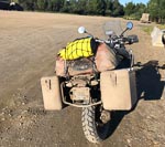
There is not much to say about today. The weather was good, the roads mostly dry and riding easy. The only record of the trials of the struggle to Deadhorse was the mud covering my motorcycle. For the first few hours this morning there were noticeably large numbers of rabbits and prairie dogs on, and beside, the road. I don't know why. But that's why the rabbit photo.
...click/tap to read the full postBack in Canada (Haines Junction, Canada)
Journal entry for Monday 16th Jul, 2018 (day 24, miles 4,559)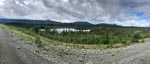
It was still somewhat wet this morning as I set off towards the Canadian Border. I was expecting to have breakfast at a place called Border City that my maps told me was just the US side of the border. I found it, but it turned out to be closed and that looked permanent. The Canadian entry station is at the town of Beaver Creek about 20 km after the actual geographic border and this town though small was definitely not closed. Three gas stations and at least two restaurants. So I chose Buckshot Betty's for one of those breakfasts I will not be allowed to have one I get home.
...click/tap to read the full postMaybe a Grizzly (Teslin, Canada)
Journal entry for Tuesday 17th Jul, 2018 (day 25, miles 4,769)
It was wet and cold pulling out of Haines Junction this morning and so the miles into Whitehorse were not about photos and sightseeing. In Whitehorse I stopped for the mandatory coffee at Starbucks, bought a few groceries and then was on my way towards Teslin.
...click/tap to read the full postBears and Bison (Laird Hot Springs, Canada)
Journal entry for Wednesday 18th Jul, 2018 (day 26, miles 3,770)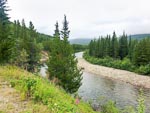
It was raining this morning so packing up my gear was a bit of a chore, trying to do everything inside the tent so as not to get all my gear wet. The rain also meant that this mornings ride was about "getting there" rather than taking in my surroundings. However after a couple of hours the rain intervals lessened and I became a little more observant of my surroundings.
...click/tap to read the full postMuncho and Stone Mountain (Fort Nelson, Canada)
Journal entry for Thursday 19th Jul, 2018 (day 27, miles 5,025)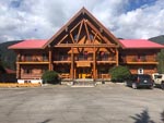
This morning as I passed Laird Hot Springs I saw that the parking lot was crammed with motorhomes and tents. Apparently a lot of people, like me, discovered the campground and lodge full last evening. However they apparently are more creative than me and simply occupied the parking lot. The crowded nature of the parking lot confirmed my decision to give the hot springs a miss. Later in the day Nina informed me that, according to the Milepost, the Laird Hot Springs is one of the most popular attractions on the ALCAN.
...click/tap to read the full postNo services for .. (Fort St John, Canada)
Journal entry for Friday 20th Jul, 2018 (day 28, miles 5,485)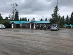
Before setting out this morning I had a conversation with a bicycle rider who had also overnighted in the campground. Turns out the guy was French and like me was headed towards Fort St John. However he expressed to me that he had a problem. Seems there is no camping ground along that route for well over 100 kilometers and that he did not want to just camp in the forest beside the road, we was nervous of bears. Well once I got under way I was immediately confronted by a sign that encapsulated the Frenchman's concern; it read Check your fuel. No services for 144 kms (thats over 110 miles). And it turned out that the sign was correct, the first fuel stop, indeed maybe even the first occupied building, was a lodge at Buckinghorse River. For me the lodge provided a welcome stop for a traditional breakfast and a place to get fuel for the next leg of the journey.
...click/tap to read the full postThe Peace (Prince George, Canada)
Journal entry for Saturday 21st Jul, 2018 (day 29, miles 5,780)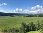
From St John this morning I back tracked a little to the start of BC Highway 29 that heads south along the Peace River to Hudson's Hope. There is obviously a political dispute surrounding the Peace River as I saw many signs arguing against the idea of a hydro power scheme on the Peace. After Hudson's Hope the route left the Peace and eventually caught up with the Pine River and followed that for miles. Today was another day of no services for ... so my French friend from Fort Nelson would have had (will have?) further camping dilemmas.
...click/tap to read the full postMt Robson (Lucerne Provincial Park, Canada)
Journal entry for Sunday 22nd Jul, 2018 (day 30, miles 6,004)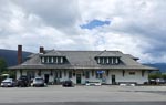
There is no doubt that today is Mount Robson day, though there were many miles between the start of day and that mountain, many miles of good road and forest (did I say forest!). Before getting to the mountain itself one drops into a valley that the locals call and signpost as Robson Valley, but which is geographically a valley of the Fraser River. In this valley I came upon the small (microscopic ?) town of McBride and stopped in at the old railway station that has been converted to a cafe and art/curio shop. Here I had a lunch of soup and toast. The cook promised me that the soup was 17 bean soup, but I could only identify two variety of beans. Never the less the soup and conversation was pleasant.
...click/tap to read the full postWaiting for weather (Jasper, Canada)
Journal entry for Monday 23rd Jul, 2018 (day 31, miles 6,041)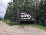
I followed Nina's advice and decided to stay in Jasper for tonight, thus making today a bit of a rest day. The hope (and forecast) is that tomorrows weather along the Icefield Parkway will be better than today. Spent the day relaxing around Jasper and the campground.
...click/tap to read the full postIcefield Parkway (Radium Hot Springs, Canada)
Journal entry for Tuesday 24th Jul, 2018 (day 32, miles 6,288)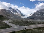
For a little while this morning the rest day gamble seemed like it might not pay off, as the mountains were all covered in cloud as I started out this morning. But by the time I got to the Columbia Icefield the cloud was broken and sun was showing through. I tried to capture a smattering of the sights along this really picturesque route. I have travelled this road a number of times but never failed to be awed by just how much spectacular mountain and lake scenery is packed into this single road.
...click/tap to read the full postRogers Pass and other things (Castlegar, Canada)
Journal entry for Wednesday 25th Jul, 2018 (day 33, miles 6,606)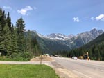
Today I was very much in the mood of "heading for home" which was remiss of me for there was a lot of great scenery along the way and I did not give it the photographic attention it deserved. From Radium this morning I made an early start and followed the Columbia River (and highway 95) north to the town of Golden a major rail head town and a watering hole on the Trans-Canada Highway (or Highway 1 as it is also called). For me it was also breakfast.
...click/tap to read the full postBack in the USA (Winthrop, USA)
Journal entry for Thursday 26th Jul, 2018 (day 34, miles 6,825)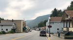
The first town on my route out of Castlegar this morning was Trail, BC. It was clearly an old mining town built in and on the sides of a steep valley with small or narrow houses. Fortunately for the town some mining and or metallurgical facilities still operates; though also clearly tourism is now a substantial income source for the area. I was intrigued by the sign at the exit to the town I did not know Italian was one of the Canadian languages.
...click/tap to read the full post