Posts for category camping
Start of a "mini adventure" (Rasar State Park, Hwy 20, USA)
Journal entry for Wednesday 6th Jul, 2016 (day 1, miles 138)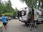
Nina and I are about start what I think of as a mini adventure. Between now and November we plan on doing some traveling in our Earthroamer. As is often the case for us the route is not well specified but will probably include a lot of time in the Western US and Western Canada. The goal of this exercise is entertainment and relaxation while my leg recovers enough to allow us to get back into the Unimog with its manual transmission and heavy clutch.
...click/tap to read the full postRe-introduction to the Cascades (Kilpchuck Forest Camp Hwy 20, USA)
Journal entry for Thursday 7th Jul, 2016 (day 2, miles 237)
It is quit a few years since we last traveled highway 20 so today was by way of a re-introduction for us to the forests and spectacular mountains of the North Cascades, not to mention a dramatic change in climate from our recent months in Phoenix.
...click/tap to read the full postDid I mention recuperation (Jone Bay Lake Roosevelt, USA)
Journal entry for Friday 8th Jul, 2016 (day 3, miles 393)
Last night camping spot (and its network of trails) gave us a chance to do a few miles of walking before we hit the road today. In case I have not mentioned it one of the goals for our mini-adventure is to see if we can maintain an exercise program while on the road. We have set this goal on previous trips but never seem to be able to stick to it. This time though there is added incentive and I need to exercise my recovering leg to re-build muscle and get some flexibility back into the damaged ankle. Thats the "recuperation" bit.
...click/tap to read the full postSpokane River Walk (Beauty Creek Camp, USA)
Journal entry for Saturday 9th Jul, 2016 (day 4, miles 524)
Spokane's River Walk provided the setting for todays entertainment and exercise. In addition to a nice 3 mile walk we got some sun (warn not hot), were entertained by the ducks on the river, and marveled at the competitiveness of young children as they raced stroller-bikes around a temporary track in the park beside the river. For those of you (like us) that do not know what stroller bikes are - they are bicycles without pedals that are propelled by pushing ones feet against the ground.
...click/tap to read the full postThe back blocks of Northern Idaho (Elk River Campground, USA)
Journal entry for Sunday 10th Jul, 2016 (day 6, miles 636)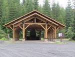
Today we were on the western side of the Clearwater National Forest south of Coeur D'Alene. Our route was south-ish and took us through interminable evergreen forests, on well made and maintained roads with little traffic. There was not much of specific note and as a result no photos for today.
...click/tap to read the full postA camp fire and hair cut (Nelson Creek Hwy 14, USA)
Journal entry for Monday 11th Jul, 2016 (day 7, miles 736)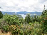
The highlight of this mornings travel was the Dent Bridge on the forest road between Elk River and Orofino, it spans the North Fork of the Clearwater River behind Dworshak dam and reservoir. Seems like this bridge is a big deal to the locals in terms of providing a shorter route from the Elk River region into Orofino, though we thought the description of the bridge(on one of the info signs) and "one of the most beautiful structures in America" was a bit excessive.
...click/tap to read the full postRoad Closed (Johnson Bar CG, USA)
Journal entry for Tuesday 12th Jul, 2016 (day 8, miles 892)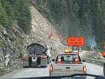
Some distance east of last nights our camp we came upon a couple of work crews fixing the road. The first of these was a small affair where a side creek had washed away the pavement. But the second was a major job. It seemed like an entire hillside had collapsed and slid over the road and there was a large crew of workmen, heavy machinery, and gravel trucks clearing the road and rebuilding the hillside. We had to wait a while at the western side of this work area for a pilot car to lead us through the workings.
...click/tap to read the full postPhotogenic little ctitters (Norton CG, USA)
Journal entry for Wednesday 13th Jul, 2016 (day 8, miles 1,060)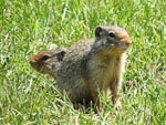
As you can see from the photos we spent a pleasant little interlude with a village of prairie dogs (I think they are prairie dogs?), we got their photos and they got bread. Seems like a reasonable trade, we guess "feeding the critters" is a common activity at this rest area (summit of Lolo Pass Hwy 12 MT).
...click/tap to read the full postA couple of big horns (Lower Seymor Lake, USA)
Journal entry for Thursday 14th Jul, 2016 (day 9, miles 1,163)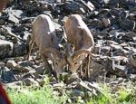
This morning we followed a picturesque, but sometimes primitive, road along the banks of Rock Creek (in the Rock Creek Recreation Area, part of Beaverhead Deer Lodge NF). Beautiful scenery, perfect weather and even a couple of big horn sheep (making the most of a 'lick' left by a local farmer).
...click/tap to read the full postWisdom and new caps (Shoup Bridge Camp, USA)
Journal entry for Friday 15th Jul, 2016 (day 11, miles 1,278)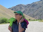
We finally got to the little town of Wisdom. MT this morning. We have in a very round about way) been heading towards this little town for the past week. Why you might ask, well in 2009 (on our Americas trip) Nina bought a purple cap covered in small mirrors in a store in this town. Later on that trip she exchanged it with a Peruvian lady for one of their local straw hats. Hence we were keen to get back to Wisdom to "get another". The store where the original hat was bought burned down 5 years ago but a new shop has been built on a nearby site and they had only two of the mirror covered caps left, both in shades of green.
...click/tap to read the full postA day of repairs (Rainbow Point, USA)
Journal entry for Sunday 17th Jul, 2016 (day 12, miles 1,515)
Today turned out to be a day of repairs, or is it breakages. Continuing from last nights camping spot the road into Cascade continued to be rough (lots of traffic and little maintenance of the road seems like the cause) and so we bumped over rocks and wash-boards for many hours. We visited the old mining ghost town of Deadwood, (the old hotel and a couple of other buildings are still evident),bumped into a number of groups of riders, and generally enjoyed the spectacular scenery and wonderfully sunny day.
...click/tap to read the full postThe journey continues (Rest Area on Canada 1, Canada)
Journal entry for Thursday 11th Aug, 2016 (day 17, miles 2,408)
So we are on the road again and the "journey continues". Since the last entry we have been back to our house in Washington, to undertake a series of chores that deserve no discussion. In addition we had a visit from our eldest son Brendon and we accompanied him into the mountains of British Columbia where Nina and I played support team to a brief solo mountain biking expedition.
...click/tap to read the full postHurley Wilderness (Lilloet Fire Road, Canada)
Journal entry for Sunday 14th Aug, 2016 (day 20, miles 2,728)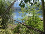
We did a bit of exploring around Gold Bridge this morning before heading down the Hurley Wilderness road, a summer only road that provides a short cut to Pemberton from Gold Bridge, it was quite rough and rocky as it seems to get a lot of traffic that is in a hurry.
...click/tap to read the full postA day in Pemberton (Twin One CG, Canada)
Journal entry for Monday 15th Aug, 2016 (day 21, miles 2,771)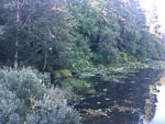
Into Pemberton this morning for the usual type of chores after a few days in the "wilderness", groceries, internet, real coffee, a visit to the Visitor Info center.
...click/tap to read the full postA few hikes (Birkenhead Lake CG, Canada)
Journal entry for Tuesday 16th Aug, 2016 (day 22, miles 2,828)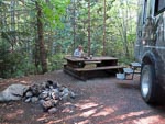
The day started with another rescue mission. One of the other campers at Twin One had managed to flatten their vehicle's battery overnight and came calling asking for a jump start; which of course we did. We like to pay it forward, we have been helped by other people many times.
...click/tap to read the full postRoast Lamb (Little Big Bar CG, Canada)
Journal entry for Saturday 20th Aug, 2016 (day 26, miles 3,059)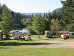
We hung around the campground this morning enjoying the nice sun and the camps wifi. In Clinton while filling up with fuel we got talking to a local guy who had ridden a motorcycle to Ushuaia, Argentina, you never can tell about people.
...click/tap to read the full postThe Mighty Fraser (Bull Canyon CG, Canada)
Journal entry for Sunday 21st Aug, 2016 (day 27, miles 3,198)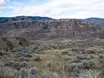
There was some cloud in the sky this morning and threat of rain (which eventually arrived) as we got onto the road for a pleasant drive through a series of valleys and eventually along an escarpment beside the Fraser River with really spectacular views. Finally the road dropped off the escarpment and down to a steel bridge across the river where to our surprise we met up with the motorcyclists from last nights camp. There after followed a discussion about our proposed route. They thought they had found the correct road but it was rough and boulder covered, so not to their liking.
...click/tap to read the full postBoring (Dugan Lake CG, Canada)
Journal entry for Monday 22nd Aug, 2016 (day 28, miles 3,287)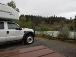
Not a very interesting day. After a fast drive from last nights camping spot (the first of the two photos below) to Williams Lake we spent over half the day in the car park of either Walmart or Canadian Tire catching up on "business".
...click/tap to read the full postMushrooms (Latremouille Lake, Canada)
Journal entry for Thursday 25th Aug, 2016 (day 31, miles 3,511)
Our backroad wanderings continued today and a series of logging and other gravel roads led us past a series of lakes. The wet nature of the countryside produced a good supply and variety of fungii and the bright sunshine had us more than a bit carried away with the photography.
...click/tap to read the full postBears and Beavers (Deadman Lake, Canada)
Journal entry for Friday 26th Aug, 2016 (day 32, miles 3,610)
We continued our wanderings this morning heading south along forest roads from Bridge Lake with the plan on getting to the area around Castle Rock Hoodoos Provincial Park. But that proved a little more challenging than we had expected as we had to reconcile differences between various maps. The result of this resolution was that we ended up traveling along Brigade Creek Fire Service Road. It was clear from the start of this 12 mile section of road that it was little used as there were no tire marks in the sand, an impression that was eventually reinforced by a series of fallen trees blocking our path. So we spent some of our time either pulling trees off the road with the front winch or simply pushing them out of the way with the front bumper. The final mile of the road was a steep descent into Deadman Creek and we were nervous for a while that we would be faced with an impassable crossing of that creek; but all was well.
...click/tap to read the full postA nice lakeside camp (Leighton Lake CG, Canada)
Journal entry for Saturday 27th Aug, 2016 (day 33, miles 3,669)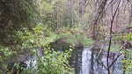
It was raining this morning, and the road was now muddy, as we traveled North along Deadman Valley to Vidette Resort. We just wanted to get as far up the valley as we could to see if we could unravel some of yesterdays navigation confusion.
...click/tap to read the full postStarting the day with a short hike (Princeton, Canada)
Journal entry for Sunday 28th Aug, 2016 (day 34, miles 3,784)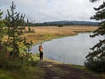
We got off to a healthy start today with a 3 mile hike around the lake, pleasant weather and nice views. Thereafter the day was about getting to Princeton. Though of course we chose not to follow the obvious highways but instead chose Kane Valley Rd, Voght Valley Rd, and Otter Lake Rd to Tulameen.
...click/tap to read the full postThe last weekend (Sugar Lake, Canada)
Journal entry for Saturday 3rd Sep, 2016 (day 40, miles 4,120)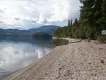
After saying our goodbyes this morning we made our way through surprisingly thick traffic into downtown Kelowna to do some shopping and then north towards Vernon before turning onto Highway 6. A little bit past Lumby we turned off the highway and headed towards Sugar Lake Recreation Area wondering whether we would be able to find a camping spot. It was, after all, the labor day weekend in a sense the last weekend of summer.
...click/tap to read the full postAnother beautiful forest walk (Crawford Bay, Canada)
Journal entry for Monday 5th Sep, 2016 (day 42, miles 4,330)
We started our day in an energetic and healthy manner taking a long walk (5 miles) along a forest track that once (before 1960) was the only access, by horse back, to the hot springs. As you can see from the photos the walk presented us with a lot of mushroom opportunities. By the time our walk was over the campground was pretty much deserted and throughout the mornings drive we saw lots of RVs and cars carrying camping gear on the road presumably heading home.
...click/tap to read the full postFirst snows (Willow Rock CG, Canada)
Journal entry for Thursday 8th Sep, 2016 (day 45, miles 4,735)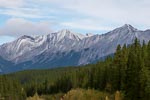
It rained a bit overnight and was overcast this morning and the road was wet and hence muddy as we continued north of 940. Late morning we connected with Highway 40 (also called the Kananaskis Trail), a spectacular drive surrounded by mountains that eventually connected with Highway 1 just east of the town of Canmore. Highway 40 provided a herd of mountain sheep for our entertainment and the first snow falls of the trip.
...click/tap to read the full postBack to the mountains (Lake Louise, Canada)
Journal entry for Monday 12th Sep, 2016 (day 49, miles 4,982)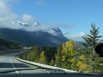
Yesterday we drove back up into the mountains and stayed at a campground in Lake Louise, but no photos as the day was a bit of a loss from the weather point of view. But today with better weather, bright sun, we backtracked a bit to visit Banff and generally absorb the spectacle of the mountains. This also gave Nina a chance to experiment with her new camera, and ask a zillion questions -- how do I &
...click/tap to read the full postThe Icefields Parkway (Jasper, Canada)
Journal entry for Tuesday 13th Sep, 2016 (day 50, miles 5,131)
Today I am going to mostly let the photos do the talking, they are more eloquent than I can be. As you might guess from those same photos we started the day with a visit to the lake and hotel at Lake Louise and then drove the Icefield Parkway to Jasper. We were blessed with glorious weather, bright sun and not a cloud in the sky. It was an opportunity to try out Nina's new camera that we could not resist.
...click/tap to read the full postLast look (Kinky Lake, Canada)
Journal entry for Wednesday 14th Sep, 2016 (day 51, miles 5,206)
Another glorious day, though with a little cloud. We started the day with a drive on the Malign Lake Road and found a hike that took us to two lakes, Beaver Lake and Summit Lake. Again we used this as an opportunity to experiment with the new camera. This was obviously encouraged by the great light and spectacular scenery. You will note in photo 8 that with the use of the camera's panorama mode Nina was able to make 3 of me.
...click/tap to read the full postTo Edmonton (Spruce Grove CG Edmonton, Canada)
Journal entry for Thursday 15th Sep, 2016 (day 52, miles 5,390)We spent today driving the road to Edmonton. We tried in the town of Hinton to get Nina a "nail job" but all the places we tried either did not do nails anymore or were booked out. Eventually she phoned a place in Edmonton (the value of the internet) for tomorrow.
...click/tap to read the full postNina gets her nails done (Long Lake Prov. Park, Canada)
Journal entry for Friday 16th Sep, 2016 (day 53, miles 5,498)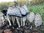
By the time the nail job was complete and we had stocked up on groceries it was after lunch. At that point we had not finally decided exactly where we would go but as the afternoon proceeded it became clear we wanted (over the coming couple of days) to go as far north as Fort McMurray.
...click/tap to read the full postBusy highway and oversized loads (Crow Lake Prov. Park, Canada)
Journal entry for Saturday 17th Sep, 2016 (day 53, miles 5,498)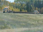
We started today with a nice long walk in the forest (and rain) near the campground and found a good example of a beaver felled tree. Once underway we made our way into the little village of Boyle for a fuel top-up before starting the stretch of road to Fort McMurray. Not far out of Boyle highway 63 turned from a rural road into a new 4 lane freeway/motorway/expressway (whatever you want to call it) clearly built to handle the demands of the energy industry, indeed we passed a number of oversized loads during the curse of the day as well as seeing many heavy transporters returning south. I was a bit captivated by the trailers and their many wheels, at one point we caught a photo of a returning combination with two prime-movers (at pulling and one pushing), 26 axles on the trailer and 8 wheels on each axle.
...click/tap to read the full postOil sands and wild fire (Engstrom Lake Prov Rec Area, Canada)
Journal entry for Sunday 18th Sep, 2016 (day 55, miles 5,614)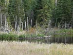
We were a bit surprised to see that there was less traffic this morning as we completed the drive into Fort McMurray. Sunday does seem to make some difference to the pace of activity in this energy boom-town area. The big interests today were oil sands and the wildfire that devastated Fort McMurray earlier in 2016.
...click/tap to read the full postBoreal forest and beaver (Winston Churchill Prov. Park, Canada)
Journal entry for Monday 19th Sep, 2016 (day 56, miles 5,895)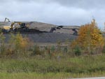
I should have mentioned the boreal forest in a earlier entry a that is what we have been traveling through the last few day. Short skinny black spruce tree, birch and aspen now turning vivid yellow and the occasional stands of larch (tamarack) that look like pine tree that are turning with the fall. Around Fort McMurray the forest was obviously burned from the wildfire earlier in the year but even in these blacked tracks there were patches of yellow and green where some trees survived and in many places under the blacked spruce new grass could be seen.
...click/tap to read the full postFarm land, boom towns, and time for laundry (Meadow Lake Prov Park, Saskatchewan)
Journal entry for Tuesday 20th Sep, 2016 (day 57, miles 6,042)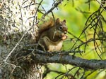
We visited the towns of Lac La Biche and Cold Lake today. A grocery resupply in La Biche and laundry in Cold Lake. They both gave the impression of being little boom towns, a small "older part of town" with lots of new shops and facilities grafted on the side. Lots of new pickup trucks and surprisingly large car dealerships.
...click/tap to read the full postShopping spree (Unnamed Campground Meadow Lake, Saskatchewan)
Journal entry for Wednesday 21st Sep, 2016 (day 58, miles 6,158)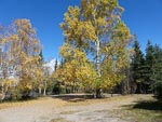
We drove all the way back to Cold Lake this morning to go on a shopping spree for some clothing. Nina needs socks and gloves and I need socks and long johns. These proved amazingly difficult to get as "the winter stuff is not in stock yet".
...click/tap to read the full postBears 4 + 1 (Lac La Plonge, Saskatchewan)
Journal entry for Thursday 22nd Sep, 2016 (day 59, miles 6,309)
We took a few photos of the campground this morning as the light was great and the water on the lake incredibly still. Thereafter a series of minor highways (!!) before joining Hwy 155 north to a place on our map called Beauval. Along 155 we saw a number of bears, one small clearly brown bear scurrying off the road away from the traffic, one black but unfortunately dead on the side of the road and just before Beauval a mother black bear and two cubs. Unfortunately no really good photos.
...click/tap to read the full postGray sky, gravel road (Gravel Pit Hwy 2, Saskatchewan)
Journal entry for Friday 23rd Sep, 2016 (day 60, miles 6,426)The sky was gray this morning as we set out along Hwy 165 and it was not long before the rain started and proceeded to set in for the day. Thus the day turned into a long drive along a surprisingly good quality gravel road.
...click/tap to read the full postIn PA (Prince Albert, Saskatchewan)
Journal entry for Saturday 24th Sep, 2016 (day 61, miles 6,541)It was still raining this morning with a light mist so that driving south towards Prince Albert was like being in a green/grey tunnel.
...click/tap to read the full postScenic road (Baldy Lake, Saskatchewan)
Journal entry for Sunday 25th Sep, 2016 (day 62, miles 6,654)
Today turned out to be sunny, as predicted by the weather app on our phones and making it a good day for us to leave Prince Alert and travel the section of Highway 120 to Candle Lake which was marked as a scenic road on one of our maps. The good light also gave Nina a chance to get a few photos of the PA Exhibition grounds and some of its more notable sights.
...click/tap to read the full postLarch trees and lakes (Hanson Lake, Saskatchewan)
Journal entry for Monday 26th Sep, 2016 (day 63, miles 6,799)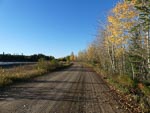
We got a bit obsessed today with both Larch trees (also called tamarack) and lakes. Why you might ask. Well the larch trees are abundant along the side of the highway, some green and others various shades of yellow. We spent a good deal of time photographing them in the hope of capturing the color and structure of these beautiful trees. Also later we discovered from google that they are the only deciduous conifer, dropping their needles in the winer after turning yellow. There was also a touch of nostalgia for us in these trees as we drove through many Larch forests in Mongolia in 2013.
...click/tap to read the full postWater falls, graffiti and Thompson (Thompson, Manitoba)
Journal entry for Wednesday 28th Sep, 2016 (day 65, miles 7,130)
We were surprised this morning to find two side excursions to water falls (Wekusko Falls, and Pisew Falls), surprised because the land seems so flat that we had trouble imagining that anything could fall. But we should not have been surprised As these falls were not distinguished by the height of the fall but by the volume of water and power of the flow. Pisew Falls in particular was very impressive and unusually even Nina was impressed.
...click/tap to read the full postOld Russian/Ukrainian (?) church (Winnipegosis, Manitoba)
Journal entry for Sunday 2nd Oct, 2016 (day 69, miles 7,620)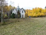
Still heading towards Winnipeg through the "lakes district". The weather was generally dreary today with lots of rain and often very heavy.
...click/tap to read the full postCemetery (Hwy 5 West of Cavalier, USA)
Journal entry for Tuesday 11th Oct, 2016 (day 78, miles 8,272)It was still raining this morning when we woke in the parking lot at Winnipeg airport so we were quite keen to get going in the hope that the weather would be better farther south. That was not to be however. Once across the border into the US we left the interstate highway and followed a series of rural roads with intermittent heavy rain. It seemed to be harvesting season for some kind of root crop in this part of North Dakota and the harvesting process covered the rural roads with a nice layer of slippery mud.
...click/tap to read the full postCountry North Dakota (New Rockford, USA)
Journal entry for Wednesday 12th Oct, 2016 (day 79, miles 8,434)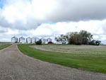
Better weather today as we continued south through ND along rural roads and flat farming country. The crops have changed a bit, more grain, and no sign of the root crops I thought we saw yesterday.
...click/tap to read the full postSunflowers (Tschedia Lake, USA)
Journal entry for Thursday 13th Oct, 2016 (day 80, miles 8,647)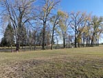
Nina started the day with a longish walk around the campground and local area (and has included a bunch of photos of last nights camping spot in todays entry). Another sunny day and again we are traveling south through ND. Today we passed many fields of sunflower that seem completely dried out and are a dark brown color. Initially when we saw the first of these fields from a distance we thought it was freshly plowed ground.
...click/tap to read the full postWall drug, the badlands (Badlands National Park, USA)
Journal entry for Friday 14th Oct, 2016 (day 81, miles 8,912)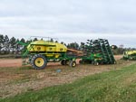
We transitioned into South Dakota today and towards the end of the day we pulled into the little town of Wall SD, which if you probably know is famous for Wall Drug, a unique style of business that started life as a real (and unsuccessful) drug store back in the 1930s. Unsuccessful that is until the owners decided to offer passing travelers free ice water. Today it is a massive complex of mismatched buildings selling all kinds of stuff from junky souvenirs to high end leather goods, ice cream and fast food. Since its first founding two nearby tourist attractions (Mount Rushmore and The Badlands National Park) have come into existence and one assumes they contribute significantly to the evident success of Wall Drug.
...click/tap to read the full postOne last look at the Badlands (Oliver Reservoir, Canada)
Journal entry for Saturday 15th Oct, 2016 (day 82, miles 9,236)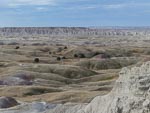
We spent sometime this morning exploring the badlands hoping for some good light and then it was "hit the road"
...click/tap to read the full postA day in Boulder (St Vrain SP, Colombia)
Journal entry for Sunday 16th Oct, 2016 (day 83, miles 9,493)We made an early start this morning in order to cover the distance to Boulder by lunch time. We had arranged to meet up with some friends of ours (John and Ursula) who are now living in Bolder. We last met up with these guys in Munich in early 2014. We had a nice visit and were particularly interested to hear why they chose Boulder as there retirement location.
...click/tap to read the full postA visit with Rob (Rio Grande, Colombia)
Journal entry for Tuesday 18th Oct, 2016 (day 85, miles 9,902)
We got an early start this morning from Limon in order to make our way to La Junta CO where we had arranged to spend a few hours and have lunch with our friend Rob Pickering of Terry Lee Enterprises and renowned Unimog fixer and finder. We had a great visit catching up with developments in Rob's life and business.
...click/tap to read the full postA walk in the hoodoos (Bisti Badland, Colombia)
Journal entry for Wednesday 19th Oct, 2016 (day 86, miles 9,150)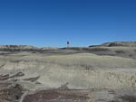
Today was another longer day of driving than we prefer but there was a goal and it was the Bisti Badlands also known as De-Na-Zin. Nina heard about this area of hoodoos and weird rock structures at this years Overland Expo West and was determined to visit and take photos. So mid afternoon we found ourselves heading south on 371, south of Farmington NM looking for the turn east that would take us to the first of the access areas. Once in the parking lot we set off on a hike of a couple of hours east into the heart of the "badlands".
...click/tap to read the full postLos Alamos, Bradbury Museum (Roadside stop near Santa Fe, Colombia)
Journal entry for Thursday 20th Oct, 2016 (day 87, miles 10,340)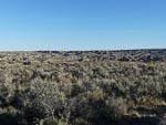
This morning brought another hike to explore the badlands, however this time we went rugged up as the morning temperature was 32°F. We spent another couple of hours this time walking across the plateau of the badlands to a couple of lookouts. After our walk, and over breakfast, we decided to devote the remainder of the day to visiting Los Alamos and its Science Museum.
...click/tap to read the full postEl Morro (El Morro Nat Mon, USA)
Journal entry for Friday 21st Oct, 2016 (day 88, miles 10,504)
After a restful night in our roadside stop we made our way south to I40 and followed it for a while to the town of Grants where Nina took the opportunity to take a walk around the little town and captured some photos of the town's decorative water feature. From Grants we turned south along NM53 looking for a place to spend the night. As we traveled 53 we started seeing signs for The Ice Caves and since there was no way there could be ice in this hot climate started discussing what they could really be. Thus intrigued, when we finally got to the gates of Ice Caves (a privately owned and run tourist attraction) we went in to investigate and discovered that there really was ice, but more of that in tomorrows entry as for now we needed to find a camping spot for the night.
...click/tap to read the full postIce Caves ! (Concho Valley, USA)
Journal entry for Saturday 22nd Oct, 2016 (day 89, miles 10,643)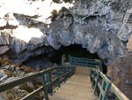
Today was a real sight-seeing day. We started by returning to those Ice Caves and discovered that there really is a cave with natural ice in it. Indeed we eventually discovered that back in the early part of the 20th century before this area had electricity and refrigerators the ice was mined to supply the iceboxes of local inhabitants. Apparently the mining ceased in the late 1940s and since that time the ice has recovered and there is more of it today then there was in those days. Is seems I may have confused some readers. Despite the heading to this entry (Concho AZ) the Ice caves are actually in New Mexico. The apparent mistake is a conflict between where we were traveling during the day and where we stayed the night. The heading to the entry gives the name of the place we spent the night.
...click/tap to read the full postA few days in Phoenix (Apache Junction, USA)
Journal entry for Sunday 23rd Oct, 2016 (day 92, miles 10,814)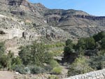
Today we were headed towards Phoenix and a couple of days of business. From Cocho Valley (on AZ61) we made our way to Show Low and picked up AZ 60 to Globe and then into the KOA at Apache Junction. We have traveled this route a number of times but even so the spectacular Snake River valley is worth a stop and a few photos.
...click/tap to read the full post