Posts From NewFoundland
The Rock, veggie patches, fire wood and Vikings (Hwy 432, NewFoundland)
Journal entry for Friday 10th Aug, 2012 (day 37, miles 5,972)
Disembarking the ferry at St Barbe we headed north following Highway 430 (called the Viking Route). For 20km the road followed the coast through well manicured villages and attractive though bleak and windswept coast and then headed inland. Along the roadside we encountered two sights that required later explanation from a local. The first were many areas set aside for the storage of firewood, some areas were well organized while others less so. We learned that these are generally personal (family) firewood supplies. NewFoundlanders are allowed to cut firewood in the forests and store near where it is cut for later use as winter heating. The second sight was more perplexing. We saw small plots of vegetable gardens beside the road. Later explanation informed us that, NewFoundland is known as The Rock for good reason; real soil is almost non-existent on the island. It happens that the construction of roadways creates a small area of fertile soil in the ditch beside the road. Locals make use of this rare soil and grow root vegetables there.
...click/tap to read the full postEarliest inhabitants (Shallow Bay, NewFoundland)
Journal entry for Saturday 11th Aug, 2012 (day 38, miles 6,160)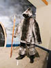
Traveling south today eventually brought us to the town and historic site of Port aux Choix, a prominent headland on the west coast of NewFoundlands Northern Peninsula. At this site Archeologists have found evidence of human habitation dating back 4400 years and almost continuous habitation since that time by no less than 5 different groups. The original peoples were a maritime culture (meaning they lived on fish and other sea food), these were replaced as the climate grew colder by two different groups of paleo-Eskimo peoples that lived on sea mammals. These in turn were replaced, as the climate warmed, by more modern Indian peoples. The 5th group was obviously European.
...click/tap to read the full postGros Morne, fellow travelers (Lomond CG, NewFoundland)
Journal entry for Sunday 12th Aug, 2012 (day 39, miles 6,255)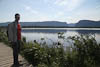
Gros Morne National Park is perhaps the premier park in NewFoundland. It is a massive granite mountain range that protrudes as much as 2000 ft above the coastal plain and is cut by steep fjord like valleys. One of the pieces of this mountain complex is famous among geologist as it is up-thrusted ocean floor. Study of these rocks (apparently) helped found the theory of plate tectonics.
...click/tap to read the full postA rainy travel day (Norris Arm, NewFoundland)
Journal entry for Monday 13th Aug, 2012 (day 40, miles 6,441)Overnight the weather turned to rain and low cloud. That is the way it persisted all day as we traveled east. At Deer lake we picked up Canada's Highway 1 (or the THC as the signs here call it - Trans-Canada-Highway, we have not seen this road since Quebec City) and followed it all day until our campsite in the forest beside a pipeline near Norris Arm.
...click/tap to read the full postGeorges tire shop (Butter Pot CG, NewFoundland)
Journal entry for Tuesday 14th Aug, 2012 (day 41, miles 6,499)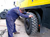
Fog and rain diverted us this morning and we abandoned our plans to visit Twillingate. We consoled ourselves with the observation that both the Iceberg and Whale seasons are already over. Instead we headed into Gander to find a truck tire shop and to have the two drivers side tires swapped or 'rotated'. After some searching we found Professional Tire Service and its owner George who quickly had the beast jacked up and the tires off and swapped around. It was interesting to watch the workmen maneuver the heavy tires on-and-off the hubs with the dexterous use of a large tire iron. I think I will have to find a place to practice.
...click/tap to read the full postMost easterly point, Signal Hill, Quidi Vidi, fish and chips (St John, NewFoundland)
Journal entry for Wednesday 15th Aug, 2012 (day 42, miles 6,775)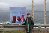
A packed day of sightseeing. We started with Cape Spear the most easterly point on the North American continent. The weather did not cooperate as it was wet and windy, but that did not reduce our enthusiasm. We see this as the start of our East-West journey around the world, so in that sense today was the start of the "real" trip.
...click/tap to read the full postSea birds, a night on a ferry (Argentia Ferry, NewFoundland)
Journal entry for Thursday 16th Aug, 2012 (day 43, miles 6,942)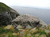
Today we were scheduled to take the ferry from Argentia, NewFoundland to North Sydney, Nova Scotia. However yesterday Nina decided that she wanted to visit Cape St Mary's Ecological Reserve before we arrived at the ferry. This entailed an early start to the day, so by 5:30 am we were on the road. St Mary's Reserve is at the end of a very scenic coastal road that passes through a mix of open moor land and low forests that is sparcely populated. The reserve itself is on the barren headland of Cape St Mary's and is marked by a small collection of buildings and a still operational lighthouse. From the Reserve entrance it is a short walk to the bird colonies that make this place famous. Crowded onto one pinnacle of rock (and overflowing onto surrounding cliffs) are 5 different species of birds estimated to number something like 70,000 in total. The birds seem to understand that their rock tower affords them protection because our mainland cliff top, vantage point was only about 100ft from the colony but they seemed to take no notice of us.
...click/tap to read the full post