Posts for October, 2012
The Gold Belt Tour, Phantom, Victor, America Eagles (Victor, USA)
Journal entry for Monday 1st Oct, 2012 (day 89, miles 11,493)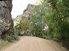
The Gold Belt Tour is a linked series of roads connecting the towns of Florence, Canon City, Victor, and Cripple Creek. We had been debating for some days whether we would attempt the Phantom Canyon Road (one of the Gold Belt Tour roads), and today decided in the affirmative. Why the debate? Well the guide book Nina has been reading points out that there are two tunnels along the road (something that is usually an issue for us) that the road is narrow, twisting and unsuitable for long vehicles (over 25ft). The road turned out to be fabulous. It is, as advertised, twisting and in places very narrow. Most of it is an old railway bed and in places where the road runs through cuts in large rocks it has not been widened since its railways days. For miles it runs along a narrow man made ledge on the side of a steep valleys; it was exhilarating.
...click/tap to read the full postThe Shelf Road (San Isabel NF, USA)
Journal entry for Tuesday 2nd Oct, 2012 (day 90, miles 11,578)
We met the fox in the parking lot of the American Eagles Overlook he was very bold and followed us around while we tried to use the morning light to get some better photos of this amazing hole in the ground. I am not sure we improved on our previous efforts in regard to the open pit but we did get a better look at some of those dump trucks this morning; they make our Mog look small.
...click/tap to read the full postAutumn colors, and Sand Dunes (Sand Dune NP, USA)
Journal entry for Wednesday 3rd Oct, 2012 (day 91, miles 11,742)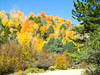
Although we did not know it at the start, today would be consumed by autumn colors, The Sangre de Cristo Mountains and the Great Sand Dune National Preserve. From our camp in the San Isabel NF (in the Wet Mountains) we passed through the town of Westcliffe (which seemed pretty much closed down for the season) and down highway 69 which travels north-south just east of the Sangre de Cristo Mountains. There are many minor roads heading west from 69 into the S de C and eventually we succumbed and started west towards Mosca Pass along CR-580. This country road changed names a number of times as it wound its way west and gradually deteriorated from a two lane black top into a narrow wheel track as it climbed to Mosca Pass at just short of 10,000 ft. Along the way we passed through farmland, open range and wonderful high alpine forest where the Aspens were displaying a wonderful mix of fall colors and providing a breath taking contrast to the dark spruce. We have been captivated by the yellow and orange colors of the Aspens for a number of days now and have been at great pains to capture these vivid colors with our camera, but they continue to prove elusive.
...click/tap to read the full postDunes, colors and a cook-up (Near Chama, USA)
Journal entry for Thursday 4th Oct, 2012 (day 92, miles 11,855)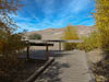
A few more photos of the Dunes and then a lengthy stop in Alamosa for laundry and then we were on our way through Southern Colorado towards New Mexico. The drive along 17 from Antonito towards Chama New Mexico took us through La Manga Pass and Cumbres Pass (both just over 10,000') and presented a wonderful display of Golden Aspen and other fall colors.
...click/tap to read the full postOur arrival at the Balloon Fiesta !! (Albuquerque, USA)
Journal entry for Friday 5th Oct, 2012 (day 93, miles 12,019)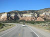
Heading down I-25 from Santa Fe to Albuquerque we were conscious of how little we knew about the Balloon Fiesta we were headed to. We had camping reservations but no idea where the campground was, we had an offer of a driveway camping spot but no address, and we had a contact at the Fiesta itself but no arrangements for meeting. But luck and the internet came to our aid. Some directions from the Fiesta website got us onto the main entrance to the Fiesta grounds, which immediately turned into an entrance line for the RV parking area (a campground without facilities). We had only been in the line a few minutes when the SUV in front stopped and our contact Scott got out and strolled back to chat to us.
...click/tap to read the full postBalloon Fiesta Day 1, Glow (Albuquerque, USA)
Journal entry for Saturday 6th Oct, 2012 (day 94, miles 12,019)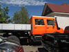
I could say "our first day at the fiesta dawned to great excitement" - but in fact we were up and going, and excited, well before dawn. Thank to Scott's hospitality we were in one of the VIP hospitality tents having breakfast at least an hour before dawn hoping (like thousands of other people) that the wind would subside so that the first mass launch of the fiesta would take place. Unfortunately the wind remained and the launch was cancelled.
...click/tap to read the full postBalloon Fiesta Day 2 - Mass launch (Albuquerque, USA)
Journal entry for Sunday 7th Oct, 2012 (day 95, miles 12,019)
This morning we knew a little more about the routine. Up just before 5:00am, onto a free shuttle bus for the 10 minute trip to the launch field, grab a seat in the hospitality tent, get some coffee and a snack and wait for the activity to start. This morning the weather gods smiled on the event and the wind was light. In waining darkness the Dawn Patrol launched (about 10 balloons that go up in advance of the mass launch to sample the flying conditions). With the Dawn patrol in the air serious action started, with many other balloons beginning the filling process, canopies inflating and their burners lighting the morning sky.
...click/tap to read the full postBalloon fiesta - Our final sessions (Chaco Canyon, USA)
Journal entry for Tuesday 9th Oct, 2012 (day 97, miles 12,019)
Monday and Tuesday are typically lower key days at the festival. The only event is the morning session (no evening display) and the format is a little different. The balloons divide themselves into two groups; those that want to compete and those that don't. The non-competitors launch from the fiesta field from dawn onwards (until about 8:00am). From 8:00am on-wards the field is closed to all balloon launches, vehicles and the public and is set up with a series of targets for competition. The competitor balloons choose a launch site at least 1 mile from the field and then attempt to fly to the field and drop a marker onto one of the targets.
...click/tap to read the full postChaco (Durango, USA)
Journal entry for Wednesday 10th Oct, 2012 (day 98, miles 12,357)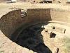
We started our brief exploration of Chaco Canyon and ruins with the usual visitor center film. This one was a bit disappointing; too much mysticism and not enough history. Though to be fair not much is really known about the people of Chaco. Some deductions from the ruins they left, a few artifacts and references in the oral histories of a number of South West tribes. However one look at the size, scope and nature of the ruins in Chaco canyon and it is evident that they were a prosperous, well organized and skilled people. The ruins on display in the canyon are called "great houses", they are large D shaped complexes with hundreds of rooms, built over succeeding generations but according to the original plan. Current archeological theory is that these buildings are ceremonial rather than domestic. Why and how did this thriving culture fall or depart; seems there is no answer to that question.
...click/tap to read the full postLaundry, chores and a chance to spread out (Haviland Lake, USA)
Journal entry for Thursday 11th Oct, 2012 (day 99, miles 12,392)
A house with a laundry and space to spread out captivated us this morning so that we did not get going until the morning was almost done. A few more shopping chores and a chance meeting with another Unimog owner and Rosie and her friends from Texas and we were really late getting underway. As a result we got only as far as Haviland Lake Campground; only about 30 miles for the day.
...click/tap to read the full postFirst signs of winter (Lizard Head Pass, USA)
Journal entry for Friday 12th Oct, 2012 (day 100, miles 12,560)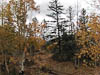
Overnight the weather turned and today we have been traveling in a mix of rain, light hail and a few snow flurries. Higher on the mountains there is a lot of fresh snow. We saw very few bright yellow Aspens today; their leaves are now mostly brown or gone. It is amazing how things have changed in a week; though of course we have moved more into the heart of the Rockies and should expect that fall/winter is more advanced here.
...click/tap to read the full postCold start, warm finish (Bushy Basin Rim, USA)
Journal entry for Saturday 13th Oct, 2012 (day 101, miles 12,711)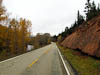
Our first touch of winter continued overnight. This morning there was a light dusting of snow on the ground and the temperature was 27°F. As we dropped down out of the mountains to the town of Dolores (SW Colorado) the scenery confirmed the approaching winter, the remaining leaves are deep red colors, the Aspens are mostly bare, and temperature stayed in the low 30s. Along the way the countryside changed from mountains to sandstone canyons. From Dolores a short drive took us to Hovenweep National Monument were we walked around the rim of a small canyon and looked at the ruins of stone buildings from the 1200's. The people that built these are the descendants of the people of Chaco. While at Hovenweep the sun made an appearance and the temperature climbed into the 50s.
...click/tap to read the full postGooseberry Rd (Mormon Pasture, USA)
Journal entry for Sunday 14th Oct, 2012 (day 102, miles 12,784)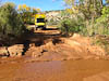
Today was spent "trying out" the truck. Our first experiment was actually to get down off our ridge top camp. The short, steep, narrow descent to highway 95 proved to be a non event but re-enforced one of yesterdays lessons; namely - over rough roads one must travel slowly. Our first stop for the day was a valley called Comb Wash were we encountered some narrow sandy trails, and a small creek crossing. The truck handled all the small obstacles without raising a sweat.
...click/tap to read the full postBeef Basin Rd (Bushy Basin Rim, USA)
Journal entry for Monday 15th Oct, 2012 (day 103, miles 12,875)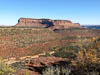
The second leg of our forest route continued North towards highway 211 and Canyonland. After a short climb out of our camp site the road traveled for a couple of hours along the rim of a number of canyons through low Juniper forests affording us great views of red sandstone cliffs, rocks valleys and Canyonland to the North.
...click/tap to read the full postMoki Dugway (Page, USA)
Journal entry for Tuesday 16th Oct, 2012 (day 104, miles 13,098)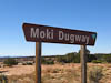
Our route from Blanding was south on 261 towards Monument Valley. Along the way we came across two spectacular but unexpected sights. The first was the (to us) oddly names Moki Dugway. This is a roadway carved into a sandstone escarpment that connects the highland plateau of the canyon land region with the lower lands of the northern Arizona Navajo Indian lands of Monument Valley. The next interesting sight was the descriptively named Gooseneck State Park. At this spot there is an overlook which gives incredible views of the twisting course of the San Jaun river before it finds its way into Lake Powell.
...click/tap to read the full postAntelope Canyon (South of Flagstaff, USA)
Journal entry for Wednesday 17th Oct, 2012 (day 105, miles 13,305)
Antelope Canyon can only be visited as part of a tour. This is partly a restriction imposed by the local Navajos who I am sure want to get revenue from visitors to the Canyon. But it is also a safety precaution as the Canyons are prone to flash flooding from distant rain falls. For example in 1997 11 visitors died when the Canyon suddenly flooded.
...click/tap to read the full post