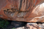
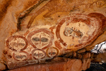
Aboriginal art
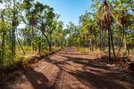
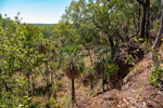
The route between Drysdale Station and the Mitchell campground consists of two road segments. From Drysdale one follows the Kalumburra Road north for 100km and then turns west onto the Mitchell Plateau track for 80km. So of course todays return journey to Drysdale reversed that route. As mentioned previously much of tne Mitchell Plateau track travels through Livistona Palm forest which we both really enjoyed. Just west of the junction of the Mitchell track and Kalumburra Road is an Aboriginal Art Site that we missed on the way up but called in on todays return.
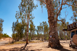
The tree with all the markers on it is in the bed of the Drysdale River not far from Drysdale Station. The markers indicate the depth of the river. The top marker is six meters or 19.5 feet. Guess that's why the road is closed during the wet season.