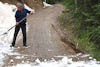
Stuck and shoveling snow again
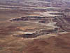
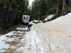
Our plan for the day was an ascent into the La Sal Mountains on the east of Moab. These are in contrast to the red rock of Moab, The Arches and Canyonland. The La Sals which range up to over 12,000 ft are green and covered in pine and aspen. Our route took us south east of Moab and up a steep forest road with some impressive switchbacks. At about 9,000 ft we passed a car containing two WA tourists who were turning back as the road was too rocky for their hire car. We (unfortunately) continued. It was not long before we were passing small mounds of snow laying across the uphill edge of the road. This is a sign that you would think we would now know and take heed but no, we continued. After passing one particularly narrow section where we were squeezed between the snow on the uphill side and a steep drop and soft edge on the downhill side we came to a bank of snow completely covering the road. Progress was stopped. So we turned out attention to retracing our path. That is reversing as there was no possible chance of turning around. Our first attempt to reverse over the previously mentioned narrow section only succeeded in starting to collapse the downhill side of the trail. A new approach was called for - digging.
After 30-40 minutes I succeeded in digging away 2-3 ft of that uphill snow bank for a distance of 40-50 feet thereby widening the road. A bit of judicious reversing and the ER was safely past the problem area. Another 10 minutes of reversing and manouvering and we were turned around and traveling comfortably.


With our attempt to cross over the La Sal range thwarted we settled for driving around them on their southern side via Utah SR46. We ambled along for the remainder of the afternoon and around 5:00pm found a nice patch of ground beside the road, UtahSR46 which had become Colorado SR90, as it desended into Paradox Valley. A few curious passersby stopped to check us out during the remainder of the afternoon-evening but we had no trouble.