What an amazing day
Sitting around camp, still buzzed from the days adventures (and maybe a little from beer and vodka), Nina and I agreed, today was one of those special travel days, a day that we will remember forever, and one of those days that will keep us thinking up new adventures.
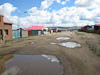
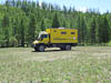
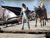
We started the day in beautiful sunshine from the Khanui River, 75 km in to what we thought would be a 300 km drive to the town of Moron. The first hour passed easily as the track followed easy country and we arrived as expected at the village of Erdemangel. A short stop at the local general store for a few supplies, some photos in the main street and we were on our way again trying to pickup that necessary track on the otherside of the village (it is interesting that navigating ones way out of a town is often diffcult). We were surprised to see construction of a number of new dwelings in the village.
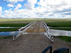
Back on the track we continued to make good progress and the next hour or so brought us to a crossing of an unnamed river. We could see the bridge, and its red and white rails, over the river from a long way out as we descended into the valley. It was only as we got right up to the bridge we saw the weight limit sign - 3.5T - so this bridge was not for us. So we forded the river a little farther upstream - no drama. We used the crossing as an excuse for morning tea and were joined for this little shot of nourishment by an elderly man who happened to be walking past as we crossed the river. We had no language in common but we still got the message across. From us the message was "come in to our house and have food", from him the message was "the road goes through that saddle you can see in the distance".
After our guest left I did a little review of our route and discovered two things that would add to the uncertainty and anxiety of the rest of the day. Firstly, Murray in Tsetserleg had given us two possible routes to follow and we were now on the one we least preferred. Our more preferred route was some 6 km to the west. The good news was that some distance ahead there seemed to be a "road" (on our map anyway) that would allow us to rejoin our preferred route, so that became the plan. Secondly, along our preferred route the road ran out. Let me explain. Up until now the GPS track(s) from Murray that we had been following closely followed some "roads" that were shown on our OSM Digital map. This duplication of track and road not only gave us comfort that we were not lost but also gave us confidence that we would be able to see enough wheel marks on the ground to follow rather than steering purely by the GPS, and also gave us confidence that the path would be navigable. Thus without the "road" we were worried that maybe our path would not be suitable. Thus with more than a little navgational anxiety we setoff on the remainder of the days travel.
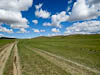
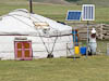

We eventually arrived at the point where we should head west to connect with our preferred route and thankfully there was a visible track. So with relief we followed it across a wide valley, up through a saddle and to our surprise dropped down into another valley and a village that was not shown on any of our maps. The last mile into the village the track traversed a muddy low area of land and we thanked the Unimog for its big wheels and diff-lockers.
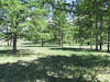
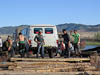
Now back on our preferred route (joined at the village) we were led up into a tight river valley and a beautiful Larch forest. We stopped for lunch on the border of the forest and watched a local herd being sheparded by a group of children over lunch.
For the next hour the track wound its way through some small but narrow valleys, with lots of side-hill (where the track is made along the the side of a hill and hence the vehicle feels like it is going to fall over), low hanging trees and other obstacles. At this point the easy to see broad expanse of well worn old wheel tracks of yesterdays travel had given way to a single set of sometimes obscure wheel tracks. It was clear that this was a much more minor road than we traveled yesterday.
We eventually got out of the Larch forest, the land openned up again into the typical broad valleys, travel became easier again and we arrived at the point where the road "ended" and our GPS track continued. To our relief we could see clear (though not abundant) wheel tracks leading off in the direction of our GPS track.
The GPS track led us across one huge valley to a pass at about 5200ft and some 25 km from the Selenge River where we thought we would spend the night. I noticed on our GPS that the river was at an alititude of 3700 ft so we joked that "we hoped the descent was gradual and navigable for us", "and further we hoped we could cross the river".
We quickly found that we were safe on count one; the descent through the valley was very gradual and as we descened we saw an increasing number of gers and herds. Interestingly we also saw quite a change in the vegetation. Our lush green grasslands of the previous days gave way to a much dryer climate with patches of sand, dry grass and many bare patches. By the time we got to the Selenge River it felt like we were in arid country. Except for the trees being the wrong kind this could have been outback NSW.
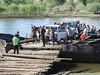
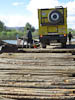
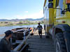
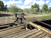
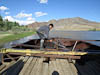
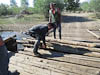
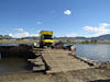
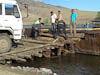
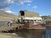
As we drew up to the river bank we both saw (and exclaimed) at the same time - "there is a ferry" - and so there was. But what a ferry it was - two rusting steel boat hulls (you could not call them boats as they had no decks) connected together by some steel girders topped with a layer of tree trunks for decking. The loading ramps were similarly constructed with a steel ramp frame decked with more tree trunks. The vessel had no power and how it managed to cross the river I will describe a little later but the thing that struck me while I sat there waiting to board/load was the way the crew pulled the vessel tight up against the loading ramp. They used an improvised capstan made from an axle shaft (welded to the vessel in a vertical orientation). Around the axle shaft was a section of steel pipe, a steel cable (with a loop in the end) was stretched from the loading ramp, wound around that piece of tube, another piece of steel (to be used as the capstan handle) was passed through the cable loop and then one of the crew wound the handle around and around tightening the cable. Simply amazing.
To say that we were a little uncertain of the capacity of this improvised vessel would be an understatement but we had no choice as the river was clearly too deep to ford. So when our turn came I followed directions drove up the bumpy ramp and onto the "deck" as instructed. I was sure I felt the deck flex under the weight of the vehicle but it did not break. With the crossing over the crew took some time to get the deck lined up with the loading ramp (as I said they had no power of any form so they simply man-handled this vessel into the correct position, then used the capstans to pull it tight against the ramp). I spent a bit of time inspecting the ramp to make sure nothing would rip a hole in our tires and once satisfied drove off - no dramas!!
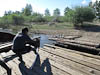
Once off the ferry we drove a few hundred meters south along the river in a stand of Cottonwood trees and parked for the night.
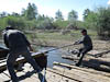
How does the ferry move?
After a drink or two we walked back to watch others use the ferry, including a sizeable cargo truck. It was then we noticed the sign that told us that someone thought the load capacity of the ferry was 18T. Yeh, right. Watching the vessel cross the river was interesting. Once ready to cross the crew would use long steel pipes as levers to move the vessel away from the loading ramp. The vessel would then move across the river being restrained from too much downstream travel by a strong steel cable across the river to which the vessel was attached by a line and pully. The return journey was achieved in exactly the same manner.
The only motive power used by the ferry for crossing in either direction was the power of the river itself - amazing.
After more watching I noticed the following additional pieces to this puzzle.
The two hulls that made up the floatation part of the ferry both seemed to have keels.
There was a rudder or tiller on the downstrean side of the ferry between the two hulls.
The crew used the rudder to angle the bows of the ferry in the direction of travel hence causing the current to produce (thanks to the existence of a keel) a lateral (that is across the river) force on the ferry.
This lateral force was what caused the motion across the river
The only other important piece to the puzzle was that large cable that crossed the river. For the physics to work the ends of that cable had to be precisely positioned, and the tensions sufficient, to ensure that only a very small amount of downstream/upstream movement was required during a crossing.
All in all an amazing piece of engineering (at least at the conceptual level).