Troglodites
This morning we spent an hour or more searching for the town of Maymand. The group of Iranians we spoke to two nights ago at the Kaluts told us that this town was a must see, so there we were, or maybe there we were not. The town was not mentioned on any of our maps, that was a good start. From the Lonely Planet Guide we found that it was north east from the town of Shahr-e Babak. So here we were this morning driving through the Shahr-e Babak with no sign (or signs to) Maymand.
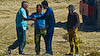
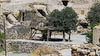
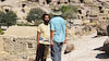
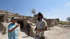
Nina's persistence came to the rescue as armed with the Lonely Planet book (which had the towns name written in Farsi) she got a series of directions that had us going in the right direction. I had to chip in by asking a road crew for additional directions (as you can see in the photo) and after a few more good samaritans (or is it good Iranians) heped us we arrived at the town. The first person we met in the town seemed to be the local guide and appeared to work for or with UNESCO in managing the town as a unique archealogical site.
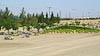
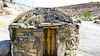
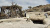
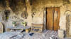
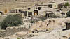
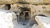
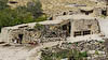
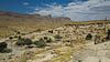
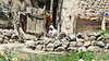
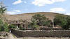
So what is so special about this town. Well from our guide we got a new word to use in describing the town - Trogloditical. Almost all the dwellings in the town are carved into a layer of soft volcanic ash. There is quite an extensive set of such dwelings, 2560 rooms in 406 cave homes. The site has been occupied for over 3000 years, and at one point over 12,000 people lived in the town whereas today there are only 20 fulltime residents.
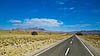
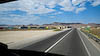
From Maymand we retraced our route back to Shahr-e babak, then north to intersect with the main road from Kerman to Yadz. We stopped about 60 km south of Yadz, well poised for an early entrance to the city of Yadz tomorrow.